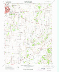
1961 Map of Urbana East
USGS Topo · Published 1974About this map
The city of Urbana serves as a major hub for the region, where the Erie Lackawanna and Penn Central railroads intersect near the Factory Pond. This mid-century survey reveals a landscape balanced between municipal growth and enduring agricultural tracts, characterized by an extensive network of rural roads like Hickory Grove Road and Dolly Varden Road. Evidence of early habitation is visible at the Indian Mound near Buck Creek, while the settlement patterns of the 1960s are anchored by outlying communities such as Mutual and Catawba Station. The map is particularly rich for genealogical research, documenting numerous burial grounds including Oakdale Cemetery, Sharon Cem, and the remote Winn Cem tucked away in Moorefield township. From the Fairgrounds in the west to the headwaters of the East Fork Buck Creek, the transition from urban industry to quiet country parishes like Moorefield Chapel is clearly defined.
Find a feature on this map
51 named features on this map. Tap any name to fly to it.
Don’t see what you’re looking for? This feature index may not catch every label — zoom into the map to look around manually.
Map Details
Editions of this 1961 Urbana East Map
4 editions found
Other maps of this area

1904 · Springfield
USGS Topo · 1:62,500

1906 · Springfield
USGS Topo · 1:62,500

1907 · South Charleston
USGS Topo · 1:62,500

1914 · St. Paris
USGS Topo · 1:62,500

1914 · Mechanicsburg
USGS Topo · 1:62,500

1916 · Mechanicsburg
USGS Topo · 1:62,500

1916 · St. Paris
USGS Topo · 1:62,500

1944 · Mechanicsburg
USGS Topo · 1:62,500

1944 · St. Paris
USGS Topo · 1:62,500

1947 · Columbus
USGS Topo · 1:250,000