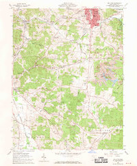
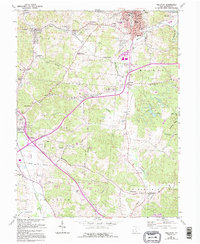
1961 Map of Wellston
USGS Topo · Published 1970About this map
Wellston sits at the heart of a landscape defined by its industrial roots and extensive coal deposits during the early 1960s. The map illustrates a complex network of rail lines, including the Baltimore and Ohio and the Chesapeake and Ohio, which serviced the surrounding mining operations. Evidence of the region's extraction history is visible in numerous strip mines scattered across the townships of Milton and Coal. Beyond the urban core, small settlements like Coalton, Glen Roy, and Tom Corwin are connected by rural routes such as Poore School Road. For genealogists, the survey identifies several family and community landmarks, including Coalton Cem, Fairmont Cemetery, and Old Bunn Cem. The presence of the Wayne National Forest on the eastern edge and the winding path of Meadow Run provide a natural contrast to the grid-patterned growth of the local townships.
Find a feature on this map
77 named features on this map. Tap any name to fly to it.
Don’t see what you’re looking for? This feature index may not catch every label — zoom into the map to look around manually.
Map Details
Editions of this 1961 Wellston Map
5 editions found
Other maps of this area

1905 · Wilkesville
USGS Topo · 1:62,500

1906 · Bidwell
USGS Topo · 1:62,500

1908 · Bidwell
USGS Topo · 1:62,500

1908 · Wilkesville
USGS Topo · 1:62,500

1912 · Oak Hill
USGS Topo · 1:62,500

1913 · Jackson
USGS Topo · 1:62,500

1944 · Jackson
USGS Topo · 1:62,500

1947 · Columbus
USGS Topo · 1:250,000

1957 · Huntington
USGS Topo · 1:250,000

1960 · Huntington
USGS Topo · 1:250,000