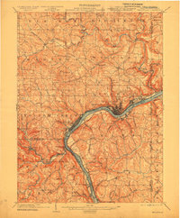
1904 Map of Wellsville
USGS Topo · Published 1915About this map
The industrial and riverine character of the tri-state border region is clearly defined by the Ohio River as it snakes through this 1904 survey. Major ceramic and manufacturing centers like East Liverpool and Wellsville anchor the riverbanks, showing their dense urban footprints before the era of modern highway expansion. The landscape is heavily marked by the infrastructure of the Cleveland and Pittsburgh RR and the Pennsylvania Co, tracing the river's path and connecting small coal and clay-working hamlets like Irondale and Empire.
Find a feature on this map
96 named features on this map. Tap any name to fly to it.
Don’t see what you’re looking for? This feature index may not catch every label — zoom into the map to look around manually.
Map Details
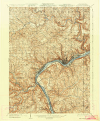
Editions of this 1904 Wellsville Map
3 editions found
Other maps of this area

1901 · Cadiz
USGS Topo · 1:62,500

1901 · Beaver
USGS Topo · 1:62,500

1902 · New Castle
USGS Topo · 1:62,500

1903 · Cadiz
USGS Topo · 1:62,500

1904 · Newcastle
USGS Topo · 1:62,500

1904 · Wellsville
USGS Topo · 1:62,500

1904 · Steubenville
USGS Topo · 1:62,500

1904 · Beaver
USGS Topo · 1:62,500

1904 · Burgettstown
USGS Topo · 1:62,500
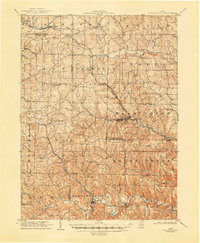
1905 · Salineville
USGS Topo · 1:62,500