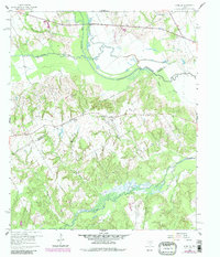
1960 Map of Winkler
USGS Topo · Published 1983About this map
Winkler sits at the heart of this landscape along the Navarro Co Freestone Co line, representing a rural Texas community during the late 1950s and early 1960s. The map captures a high density of local landmarks essential for family history research, including the Petersburg Ch, Pleasant Hill Ch, and New Hope Ch. The low-lying terrain is defined by the convergence of major waterways such as Chambers Creek and Richland Creek, which feed into the meandering path of Tehuacana Creek. A series of Drill Holes scattered across the quadrangle suggests the era's subsurface exploration and mineral interest.
Find a feature on this map
22 named features on this map. Tap any name to fly to it.
Don’t see what you’re looking for? This feature index may not catch every label — zoom into the map to look around manually.
Map Details
Editions of this 1960 Winkler Map
4 editions found
Other maps of this area

1954 · Dallas
USGS Topo · 1:250,000

1954 · Waco
USGS Topo · 1:250,000

1955 · Waco
USGS Topo · 1:250,000

1958 · Dallas
USGS Topo · 1:250,000

1959 · Powell
USGS Topo · 1:24,000

1960 · Winkler
USGS Topo · 1:24,000

1960 · Streetman
USGS Topo · 1:24,000

1960 · Creslenn Ranch
USGS Topo · 1:24,000

1960 · Goodlow Park
USGS Topo · 1:24,000

1960 · Roustabout Camp
USGS Topo · 1:24,000