1920s Maps of California
Explore 487 historic maps of California from the 1920s. These maps offer a rare glimpse into what life looked like during the 1920s — showing old roads, neighborhoods, homes, and landmarks that have changed or disappeared over time.
Whether you're researching your family's past, planning a metal detecting trip, or studying how California's landscape evolved across the 1920s, these high-resolution maps are a powerful tool for exploring the history of this region.
- Focus on a specific era: All maps on this page are from the 1920s, giving you a focused view of this time period.
- See what’s changed: Compare century-old streets, trails, and buildings to today's modern landscape using overlays and satellite layers.
- Research with precision: Use these maps for genealogy, historical research, land use analysis, or educational projects.
- View, download, or print: Maps are fully viewable online in high resolution, and can be downloaded or printed for your own records.
Start exploring California's history through authentic maps from the 1920s. This is your window into the past.
California maps
- 1920 Map of Indian Gulch
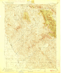 1920 Indian Gulch1920 Print · USGSMariposa County at the height of its early mining and ranching era is captured in this meticulous 1920s-era topographic survey. Researchers can trace family history at the Hornitos School or locate historic claims like the Ruth Pierce Mine and Johnnie Green Mine.3 unique versions available
 - 1920 Map of Glenblair
 1920 Glenblair1920 Print · USGSCoastal Mendocino County is seen here during the height of the early twentieth-century timber boom, where private rail lines carved through the redwood canyons. Researchers can trace the old logging camps and industrial spurs of the Albion Lumber Company and the California Western Railroad & Navigation Co through Irmulco and Northspur.
 - 1920 Map of Jamesburg
 1920 Jamesburg1920 Print · USGSMonterey County ranch lands and high forest peaks appear here as they were during the late teens. Genealogists and local historians can locate early homesteads and community hubs like Jamesburg, the Tularcitos Ranch, and several remote schoolhouses.
 - 1920 Map of Pacheco Pass
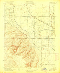
 1920 Pacheco Pass1920 Print · USGSThe Pacheco Pass gateway and the eastern Diablo Range are captured here during the early twentieth century. Researchers can trace historic local life through sites like the Bald Eagle Mine, San Luis Ranch, and Cottonwood School.4 unique versions available
 - 1920 Map of Santa Rita Bridge
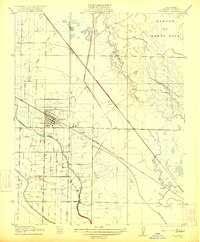
 1920 Santa Rita Bridge1920 Print · USGSThe central San Joaquin Valley appears here as an intricate network of waterways and early ranching outposts just after the turn of the century. Researchers can trace the legacy of large land holdings like Santa Rita Ranch and find specific sites like the Temple Gun Club or Lucerne Farm.
 - 1920 Map of Venado
 1920 Venado1920 Print · USGSColusa County mineral springs and mountain passes are captured here during the years following the Great War. Researchers can trace the path of the Colusa & Lake R.R. (Abandoned) and locate historic mining sites like the Abbott Mercury Mine and Wilbur Springs.
 - 1920 Map of Kismet
 1920 Kismet1920 Print · USGSMadera County’s rail-and-river geography is on full display here during the early twentieth century. Genealogists and researchers can trace the junction of the Atchison Topeka and Santa Fe at Kismet, the rural Talbot School, and the course of the Fresno River.
 - 1920 Map of Delonagha
 1920 Delonagha1920 Print · USGSThe Sierra Nevada foothills of Kern County come into focus in 1920, showing a landscape defined by the Sequoia National Forest. Researchers can trace the early layout of Glenville, identify remote outposts like Brown Mill, and locate family-named features such as Caughran Springs.
 - 1920 Map of Bonita Ranch
 1920 Bonita Ranch1920 Print · USGSMadera County agricultural land is captured here in the years following the Great War, showing a landscape defined by ranching and the Fresno River. Genealogists and historians can trace early water rights and property lines at Bonita Ranch and Rattlesnake Ranch.
 - 1920 Map of Santa Monica
 1920 Santa Monica1920 Print · USGSThe Los Angeles basin and San Fernando Valley are captured here just after the war as agriculture gives way to early suburban sprawl. Genealogists and historians can trace the early grids of Beverly Hills, Sawtelle, and Van Nuys alongside the sprawling Salt Lake Oil Fields.
 - 1920 Map of Bridgeport
 1920 Bridgeport1920 Print · USGSThe High Sierra and Mono Basin are shown here in the early twentieth century, during a peak period of mining and ranching. Researchers can locate vanished camps like Star City, trace the California Masonic Road, and find family names at Conway Ranch.
 - 1920 Map of Pt. Delagda
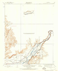
 1920 Pt. Delagda1920 Print · USGSThe Humboldt County coast in the years following the Great War remained a remote landscape of family-run operations and steep shorelines. Researchers can trace early ranching sites and coastal landmarks like Shelter Cove, Etters Ranch, and Honey Dew.
 - 1920 Map of Healdsburg
 1920 Healdsburg1920 Print · USGSThe Russian River valley in the early twentieth century was a landscape of expanding viticulture and rail transit. Genealogists and historians can trace the old depots and homesteads from Geyserville to Windsor, finding specific landmarks like the Orphans Home and Olive Hill Cem.
 - 1920 Map of Cummings
 1920 Cummings1920 Print · USGSMendocino County ranching and transit corridors are captured in the years following the Great War as the modern highway began to take shape. Genealogists and historians can locate family holdings like Buckhorn Ranch and Spittler Ranch alongside early settlements at Bell Springs and Cummings.
 - 1920 Map of Carrisalito Spring
 1920 Carrisalito Spring1920 Print · USGSMerced County's rugged foothills and early oil infrastructure appear in this 1920s survey. Researchers can trace remote landmarks like the Ortigalita School, the Carrisalito Spring, and an early Oil Pump Sta.
 - 1920 Map of Ukiah
 1920 Ukiah1920 Print · USGSMendocino County life centers on the Russian River valley during the years following the first World War. Family historians can locate specific homesteads like Roderis Ranch and trace rail operations at El Roble Siding or Clemhurst Spur.
 - 1920 Map of Covelo
 1920 Covelo1920 Print · USGSTracing the Eel River in the early twentieth century, this military survey reveals the remote homesteads and rail infrastructure of Mendocino County. Genealogists can locate family-named sites like Fred Simmerly Sr and Nash along the Northwestern Pacific Railroad.
 - 1920 Map of Harris
 1920 Harris1920 Print · USGSHumboldt County ranching and rail life are recorded here during the early twentieth century as the railroad carved its path through the Eel River canyon. Researchers can trace historic family holdings like Carey Ranch or locate early industrial sites such as the Steelhead US Fish Hatchery and Fort Seward.
 - 1920 Map of Fort Bragg, 1928 Print
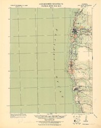 1920 Fort Bragg1928 Print · USGSThe Mendocino coast in the early twentieth century reveals a rugged network of timber ports and pioneer rail lines. Genealogists and historians can trace the early footprints of Fort Bragg, the Cal Western R R & Nav Co railroad, and the historic lighthouse area at Pt. Cabrillo.
 - 1920 Map of Orangedale School, 1957 Print
 1920 Orangedale School1957 Print · USGSThe foothills of eastern Fresno County meet the valley floor in the 1920s as a complex network of irrigation canals begins to reshape the land. Genealogists and local historians can trace the rail-and-river economy through the Atchison Topeka and Santa Fe line and settlements like Piedra, Avocado, and Gravesboro.
 - 1921 Map of Volta
 1921 Volta1921 Print · USGSMerced County agriculture and rail transit are in focus during the early twenties as irrigation reshapes the valley floor. Genealogists and historians can locate the Volta rail stop, the rural Monroe School, and the path of the San Joaquin and Kings River Canal.
 - 1921 Map of Shasta Valley Sheet No 7
 1921 Shasta Valley Sheet No 71921 Print · USGSShasta Valley was undergoing significant irrigation planning in the early 1920s as ranching families established themselves in Siskiyou County. You can trace early water sources and landholdings like Dukes Ranch, Big Springs, and the Little Shasta River.
 - 1921 Map of Cape San Martin
 1921 Cape San Martin1921 Print · USGSThe Big Sur coast and its remote mining interior are documented here during the early twenties, prior to the construction of the modern highway. Local historians can trace family operations like the Krenkels Ranch or investigate the gold-mining era at the Los Burros Mine and the Calizona Mines.6 unique versions available
 - 1921 Map of Jamesburg
 1921 Jamesburg1921 Print · USGSCoastal mountains and remote ranchlands define this part of Monterey County in the early twenties. Researchers can trace the placement of Tularcitos School, family estates like Tularcitos Ranch, and landmarks like Uncle Sam Mtn.5 unique versions available
 - 1921 Map of Los Banos
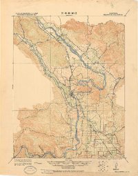
 1921 Los Banos1921 Print · USGSLos Banos and the surrounding Merced County ranch lands are captured here during the early twentieth-century expansion of Central Valley irrigation. Family historians and researchers can trace the Southern Pacific rail corridor, the Center School, and rural landings like Abbat and Gudwall.2 unique versions available
Showing maps 1-25
Top cities of California
- Los Angeles historical maps
- San Diego historical maps
- San Jose historical maps
- San Francisco historical maps
- Fresno historical maps
- Sacramento historical maps
See more
Top counties of California
- San Diego County historical maps
- Orange County historical maps
- San Bernardino County historical maps
- Santa Clara County historical maps
- Alameda County historical maps
- Sacramento County historical maps
See more
Frequently asked questions
- What are the different types of historical maps available for California?
- What is the oldest map of California?
- Where can I purchase historical maps of California for my home or office?
- Where can I download high-res historical maps of California?
- Are there historical topographic maps available for California?
- Is there historical aerial imagery available for California?
- Where are historical maps of California sourced from?