1910s Maps of California
Explore 259 historic maps of California from the 1910s. These maps offer a rare glimpse into what life looked like during the 1910s — showing old roads, neighborhoods, homes, and landmarks that have changed or disappeared over time.
Whether you're researching your family's past, planning a metal detecting trip, or studying how California's landscape evolved across the 1910s, these high-resolution maps are a powerful tool for exploring the history of this region.
- Focus on a specific era: All maps on this page are from the 1910s, giving you a focused view of this time period.
- See what’s changed: Compare century-old streets, trails, and buildings to today's modern landscape using overlays and satellite layers.
- Research with precision: Use these maps for genealogy, historical research, land use analysis, or educational projects.
- View, download, or print: Maps are fully viewable online in high resolution, and can be downloaded or printed for your own records.
Start exploring California's history through authentic maps from the 1910s. This is your window into the past.
California maps
(259)- 1910 Map of New Hope
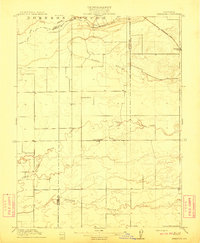
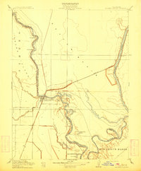
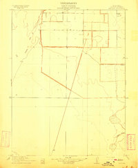
 1910 New Hope1910 Print · USGSThe California Delta at the start of the twentieth century was a complex network of reclaimed islands and vital waterways. Genealogists and local historians can trace the early community at New Hope and its New Hope School, or locate landings along the Mokelumne River.2 unique versions available
 - 1910 Map of Sheridan
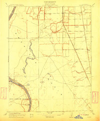
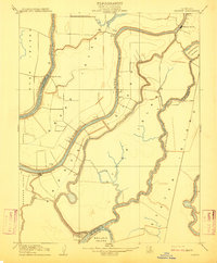
 1910 Sheridan1910 Print · USGSNear the Placer and Sutter county line in the early 1900s, this area was a landscape of historic land grants and vital rail links. Genealogists and historians can trace the tracks of the S. P. R. R. (Marysville Line) past Sheridan and locate the rural Fairview School.2 unique versions available
 - 1910 Map of Lincoln
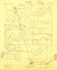
 1910 Lincoln1910 Print · USGSPlacer County's lower foothills and agricultural plains are captured here just after the turn of the century. You can trace the path of the Southern Pacific (Marysville Line) through early settlements like Sheridan and Lincoln, and locate the old Fairoaks School.2 unique versions available
 - 1910 Map of Castle
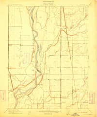
 1910 Castle1910 Print · USGSThe northern San Joaquin Valley was a landscape of transit and territory during the first decade of the twentieth century. Genealogists and historians can trace the exact routes of Cherokee Lane and the legacy of the Campo De Los Franceses land grant.2 unique versions available
 - 1910 Map of Rio Vista
 1910 Rio Vista1910 Print · USGSThe Sacramento River delta in the early twentieth century was a complex network of island farms and winding waterways. Genealogists and historians can trace old settlements like Rio Vista and Newtown, or locate the specific Blacksmith Shop in the foothills.2 unique versions available
 - 1910 Map of Furnace Creek
 1910 Furnace Creek1910 Print · USGSThe Nevada and California borderlands thrive during a historic mining boom in this early twentieth-century survey. Researchers can trace the rise of desert settlements like Rhyolite and Gold Center or locate industrial sites such as the Keane Wonder Mine and Borax Mill.5 unique versions available
 - 1910 Map of Gonzales
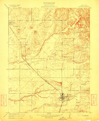
 1910 Gonzales1910 Print · USGSThe Salinas Valley agricultural corridor comes to life in the early 1910s, defined by massive land grant tracts and early rail infrastructure. Genealogists and historians can trace the footprint of early Gonzales, the rural Gloria School, and the Southern Pacific rail line.
 - 1910 Map of Wheatland
 1910 Wheatland1910 Print · USGSThe Wheatland area at the dawn of the twentieth century was a landscape of expansive ranching lands and developing rail corridors. Researchers can trace the massive Johnson Rancho boundary, locate the Eagle School, and find the early settlement of Horstville.2 unique versions available
 - 1910 Map of Salinas
 1910 Salinas1910 Print · USGSThe Salinas Valley thrives at the turn of the century as a burgeoning agricultural and rail hub. Genealogists can trace family holdings and rural landmarks like Simon Castros, Confederate Corners, and the narrow-gauge Pajaro Valley Consolidated RR.
 - 1910 Map of Bouldin
 1910 Bouldin1910 Print · USGSThe Sacramento-San Joaquin Delta at the turn of the century is a labyrinth of reclaimed island tracts and sloughs. Trace the early river landings at Central Landing and Blakes Landing, or locate the Old Cannery along the South Fork Mokelumne River.3 unique versions available
 - 1910 Map of Jersey
 1910 Jersey1910 Print · USGSThe California Delta at the start of the century was a landscape of river-bound islands and vital steamboat landings. Genealogists and historians can trace old waterfront sites like Larsen Landing and Jersey, or the rail path of the A T and S F R R.3 unique versions available
 - 1910 Map of Knights Landing
 1910 Knights Landing1910 Print · USGSIn the early 1900s, the Sacramento Valley landscape was a network of winding river bends and sloughs centered on the rail-and-river hub of Knights Landing. You can trace old waterways and rail lines like the Southern Pacific Branch and search for family landmarks near Mc Griff Lakes or Mary Lake.2 unique versions available
 - 1910 Map of Woodbridge
 1910 Woodbridge1910 Print · USGSSan Joaquin and Sacramento counties are captured here at the height of their early rail-and-river era. Genealogists and historians can trace the early streets of Lodi, the riverside blocks of Woodbridge, and rural landmarks like North School and Tracy Lake.2 unique versions available
 - 1910 Map of Bruceville
 1910 Bruceville1910 Print · USGSThe Sacramento County delta country is captured here in the early twentieth century as a landscape of new railways and traditional wineries. Trace the early days of Bruceville and Bradford Winery, or locate rural landmarks like the Point Pleasant School and Bear Lake.2 unique versions available
 - 1910 Map of Roseville
 1910 Roseville1910 Print · USGSRoseville was a burgeoning railroad town when this 1908 survey recorded its early street grid and rail junctions. Trace the tracks of the Southern Pacific through Whitney or locate rural landmarks like the Pleasant Grove School and Kaseberg farm.2 unique versions available
 - 1910 Map of Vernon
 1910 Vernon1910 Print · USGSThe river-and-rail economy of Sutter County comes alive in the early 1900s at the confluence of the Sacramento and Feather rivers. Researchers can trace the landing sites at Vernon Landing, early post offices like Vernon Verona P. O., and rural schoolhouses such as Lee School.2 unique versions available
 - 1910 Map of Headreach
 1910 Headreach1910 Print · USGSThe California Delta's intricate waterway network is revealed in this 1910 survey, showcasing the early landscape of San Joaquin County. Trace the river economy through landings like Terminous and Headreach Landing or the winding paths of Potato Slough and White Slough.2 unique versions available
 - 1910 Map of Galt
 1910 Galt1910 Print · USGSGalt and the surrounding Sacramento Valley are captured here in the early twentieth century as the railroad transformed rural life. Genealogists and local historians can trace the early rail stops at McConnell and Arno or locate the historic Arno School.2 unique versions available
 - 1910 Map of Nicolaus
 1910 Nicolaus1910 Print · USGSSutter County thrives at the junction of the Feather and Bear rivers during the early 1900s rail expansion. Genealogy and local history researchers can trace old rail stops at Nicolaus Sta and Rio Oso or locate landmarks like the Illinois School.2 unique versions available
 - 1910 Map of Pleasant Grove
 1910 Pleasant Grove1910 Print · USGSThe Sacramento Valley landscape near the Sutter and Placer county line appears here in the early twentieth century, dominated by agricultural plains and interurban rail. Researchers can trace the early path of the Northern Electric RR and find rural landmarks like Eagle School and Alpha School.2 unique versions available
 - 1910 Map of Marcuse
 1910 Marcuse1910 Print · USGSSutter County at the end of the Edwardian era is captured here as a grid of pioneering farms and drainage projects. Genealogists and local historians can locate early landmarks like Central School, the settlement of Marcuse, and the winding path of Nelson Slough.3 unique versions available
 - 1910 Map of Isleton
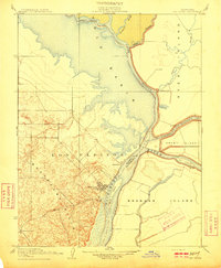
 1910 Isleton1910 Print · USGSThe California Delta's intricate landscape of reclaimed islands and sloughs is captured here just after the turn of the century. You can trace early riverfront settlements like Isleton and Walnut Grove, or locate the waterfront Golden State Cannery.3 unique versions available
 - 1910 Map of Soledad
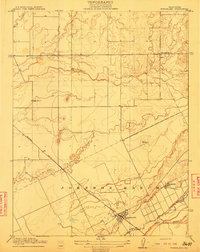
 1910 Soledad1910 Print · USGSMonterey County ranchos and valley lands appear here just after the turn of the century, as agriculture expanded along the Salinas River. Researchers can trace old property boundaries from Ex Mission Soledad and locate early sites like Camphora School and the Southern Pacific RR.
 - 1910 Map of Buena Vista Lake, 1912 Print
 1910 Buena Vista Lake1912 Print · USGSThe southern San Joaquin Valley comes to life in the years before the great lakes were drained for agriculture. Genealogists and historians can trace early rail stops like Bowerbank and Hazelton or locate rural landmarks such as the Palm School and Moron Taft P O.
 - 1910 Map of Ivanpah, 1957 Print
 1910 Ivanpah1957 Print · USGSThe Mojave high desert at the start of the twentieth century was a landscape of remote mining camps and vital railroad junctions. Trace the early industrial footprint of Vanderbilt, the Copper World Mine, and the rail stops at Nipton and Kelso.
Showing maps 1-25 of 259
Top cities of California
- Los Angeles historical maps
- San Diego historical maps
- San Jose historical maps
- San Francisco historical maps
- Fresno historical maps
- Sacramento historical maps
See more
Top counties of California
- San Diego County historical maps
- Orange County historical maps
- San Bernardino County historical maps
- Santa Clara County historical maps
- Alameda County historical maps
- Sacramento County historical maps
See more
Frequently asked questions
- What are the different types of historical maps available for California?
- What is the oldest map of California?
- Where can I purchase historical maps of California for my home or office?
- Where can I download high-res historical maps of California?
- Are there historical topographic maps available for California?
- Is there historical aerial imagery available for California?
- Where are historical maps of California sourced from?