1920s Maps of Maine
Explore 141 historic maps of Maine from the 1920s. These maps offer a rare glimpse into what life looked like during the 1920s — showing old roads, neighborhoods, homes, and landmarks that have changed or disappeared over time.
Whether you're researching your family's past, planning a metal detecting trip, or studying how Maine's landscape evolved across the 1920s, these high-resolution maps are a powerful tool for exploring the history of this region.
- Focus on a specific era: All maps on this page are from the 1920s, giving you a focused view of this time period.
- See what’s changed: Compare century-old streets, trails, and buildings to today's modern landscape using overlays and satellite layers.
- Research with precision: Use these maps for genealogy, historical research, land use analysis, or educational projects.
- View, download, or print: Maps are fully viewable online in high resolution, and can be downloaded or printed for your own records.
Start exploring Maine's history through authentic maps from the 1920s. This is your window into the past.
Maine maps
- 1920 Map of York
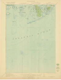
 1920 York1920 Print · USGSThe Maine and New Hampshire shoreline comes to life during the late 1910s, showing a region balanced between naval defense and coastal commerce. Genealogists and historians can locate old landmarks like the Lincoln School, the Coast Guard Sta, and the path of the Electric Railway.6 unique versions available
 - 1920 Map of Winn
 1920 Winn1920 Print · USGSPenobscot County in the years following the Great War was a landscape shaped by competing railroads and the power of the river. Genealogists and local historians can trace the early layouts of Winn, Lincoln, and Lee, or locate family landmarks near Mattanawcook Pond and Libby Corner.5 unique versions available
 - 1920 Map of Bath
 1920 Bath1920 Print · USGSCoastal Maine at the height of the rail era is captured here, showing the intricate tidal waters surrounding Bath and Brunswick. Genealogists and local historians can trace family locations near Nequasset Falls, Cundy Harbor, and the Quaker church.2 unique versions available
 - 1920 Map of Moosehead Lake, 1955 Print
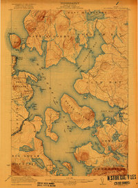
 1920 Moosehead Lake1955 Print · USGSMoosehead Lake in the early twentieth century was a hub of rail travel and island settlements accessible primarily by water. You can trace the historic Steamboat Route between Kineo Station, the Masterman School, and the remote outpost of Capens.
 - 1921 Map of Brassua Lake
 1921 Brassua Lake1921 Print · USGSThe North Maine Woods come alive in the 1920s at the intersection of the Canadian Pacific and Maine Central railroads. Genealogists and historians can trace logging-era life at Somerset Junction, Blaine School, and numerous seasonal sites like Depot Camp.3 unique versions available
 - 1921 Map of Great Wass Island
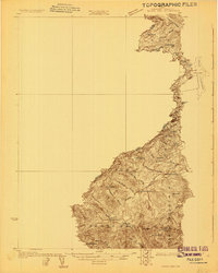
 1921 Great Wass Island1921 Print · USGSThe Washington County coast appears as a intricate maze of granite islands and narrow channels in the years following the Great War. Maritime researchers can locate the Moose Peak L H, the Coast Guard Sta, and remote harbors like Mistake Harbor.4 unique versions available
 - 1921 Map of Columbia Falls
 1921 Columbia Falls1921 Print · USGSCoastal Washington County is captured here in the early twentieth century as a busy network of river ports and rail-linked interior towns. Genealogists and historians can trace family locations through rural schoolhouses like The Basin School and maritime hubs such as Jonesport, Beals, and Columbia Falls.
 - 1921 Map of Van Buren
 1921 Van Buren1921 Print · USGSThe northern Maine border and New Brunswick frontier appear here in the early 1920s, as mapped for military strategic use. Genealogists and rail historians can trace the paths of the Grand Trunk R. R. through Van Buren and Hamlin, or locate settlements like Keegan and Bellefleur.
 - 1921 Map of Columbia Falls
 1921 Columbia Falls1921 Print · USGSCoastal Washington County at the start of the twenties reveals a landscape defined by tidal reaches and the Maine Central Railroad. Genealogists can locate family homes near Tibbetts Town, Jonesport, and numerous local schools like the White School or Monsapec School.4 unique versions available
 - 1922 Map of Moosehead Lake
 1922 Moosehead Lake1922 Print · USGSPiscataquis County’s wilderness is caught in a moment of transition during the early twenties as railroads and steamers opened the north woods. Researchers can trace the rails to Kineo Station or locate remote outposts like Masterman School and Capens.7 unique versions available
 - 1922 Map of Long Pond, 1955 Print
 1922 Long Pond1955 Print · USGSThe Maine north woods in the early twenties reveals a landscape defined by the Canadian Pacific rail line and the timber industry. Genealogists and historians can trace family-named sites like Fogg Farm, Mackamp, and Jackman Mill.5 unique versions available
 - 1923 Map of Brassua Lake
 1923 Brassua Lake1923 Print · USGSRailroads and river routes intersect in the Maine north woods at the start of the 1920s. Genealogists and historians can trace the junction of the Canadian Pacific at Somerset Junction Tarratine PO and locate remote outposts like Blaine School and Cornish Farm.4 unique versions available
 - 1923 Map of Attean, 1965 Print
 1923 Attean1965 Print · USGSSomerset County's wilderness is captured here in the 1920s, showcasing a network of remote outposts and waterways along the international border. Genealogists and historians can trace the Canadian Pacific line to Jackman Station, Boston Ranch, and the Stetson School.2 unique versions available
 - 1924 Map of Farmington
 1924 Farmington1924 Print · USGSFranklin County in the early 1920s is a landscape of river-powered mills and intersecting rail lines, including the Sandy River and Rangeley Lakes RR. Genealogists can locate dozens of country schools and rural settlements like Allens Mills and Knowltons Corner.6 unique versions available
 - 1924 Map of Long Pond
 1924 Long Pond1924 Print · USGSSomerset County’s timber and rail landscape is captured here in the early twenties as the logging and sporting industries thrived. Trace the Canadian Pacific rail line through Jackman Station to remote outposts like Mackamp and the Whipple Farm.5 unique versions available
 - 1925 Map of Pierce Pond
 1925 Pierce Pond1925 Print · USGSSomerset County in the mid-twenties was a landscape of remote timberlands and sporting camps connected by river landings. Genealogists and historians can trace early wilderness outposts like Grace Pond Camp and industrial markers like Spencer Dam or the Coburn Mtn Lookout Station.2 unique versions available
 - 1925 Map of Attean
 1925 Attean1925 Print · USGSThe Maine wilderness at the Canadian border in the mid-1920s is a landscape of timber and rail. Researchers can trace the development of Jackman and Jackman Station or locate remote sites like Boston Ranch and Stetson School.6 unique versions available
 - 1926 Map of Burnham
 1926 Burnham1926 Print · USGSWaldo and Kennebec counties in the mid-1920s are captured here as a landscape of rural schoolhouses and family-named corners centered on the Sebasticook River. Genealogists can trace family roots through landmarks like Quaker Hill Church, the Freedom Town House, and dozens of district sites like Beech Hill School.3 unique versions available
 - 1926 Map of Dixfield, 1953 Print
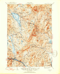 1926 Dixfield1953 Print · USGSWestern Maine's river valleys and highlands are captured here in the mid-twenties, showcasing the region's rail and timber economy. Genealogists can trace family schoolhouses like Maple Grove Sch or locate old mill sites such as Hildreths Mill near Lake Webb.2 unique versions available
 - 1927 Map of Stockholm
 1927 Stockholm1927 Print · USGSNorthern Aroostook County's borderlands and timber country are captured here in the late twenties during the height of the rail-and-river economy. Researchers can trace rural school districts like Berquist Sch, the Caniba Mill, and the Bangor and Aroostook railroad stops.
 - 1927 Map of Sandy Bay
 1927 Sandy Bay1927 Print · USGSThe Maine-Quebec borderlands appear here in the late twenties, showing the high-country landscape of Somerset County. Genealogists and researchers can locate remote outposts like Hilton Farm and landmarks such as Little Canada Falls and Isaac Kelly Notch.5 unique versions available
 - 1927 Map of Pierce Pond
 1927 Pierce Pond1927 Print · USGSThe remote Maine woods of Somerset County come alive in this mid-1920s survey of the Upper and Lower Enchanted territories. Genealogists and historians can trace early wilderness outposts like Salmon Streams Farm, West Forks, and the riverside Hayden Landing.6 unique versions available
 - 1927 Map of Katahdin
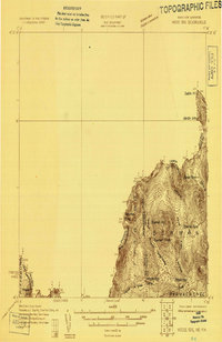
 1927 Katahdin1927 Print · USGSNorthern Maine during the late 1920s offered a landscape of wilderness outposts and towering peaks within the Katahdin Park Game Preserve. Trace old logging ways and early recreation spots like Traceys Camp, Pitmans Garage, and Monument Peak.
 - 1927 Map of Moose Bog
 1927 Moose Bog1927 Print · USGSThe wilderness of the North Woods is charted in the late twenties along the border where Maine, New Hampshire, and Quebec meet. Researchers can trace the remote Bowman Farm and the high-elevation wetlands of Moose Bog and the Third East Branch Magalloway River.3 unique versions available
 - 1927 Map of Square Lake
 1927 Square Lake1927 Print · USGSAroostook County's deep woods and connected waterways are captured here in the late 1920s, showing a landscape of timber camps and small school districts. You can trace the rural network of numbered schoolhouses and shoreline landmarks like Larriveau Mill, Red Point City, and Guerette Sch.
Showing maps 1-25
Top cities of Maine
- Portland historical maps
- Lewiston historical maps
- Bangor historical maps
- South Portland historical maps
- Auburn historical maps
- Biddeford historical maps
See more
Top counties of Maine
- Cumberland County historical maps
- York County historical maps
- Penobscot County historical maps
- Kennebec County historical maps
- Androscoggin County historical maps
- County historical maps
See more
Frequently asked questions
- What are the different types of historical maps available for Maine?
- What is the oldest map of Maine?
- Where can I purchase historical maps of Maine for my home or office?
- Where can I download high-res historical maps of Maine?
- Are there historical topographic maps available for Maine?
- Is there historical aerial imagery available for Maine?
- Where are historical maps of Maine sourced from?