1990s Maps of Maine
Explore 95 historic maps of Maine from the 1990s. These maps offer a rare glimpse into what life looked like during the 1990s — showing old roads, neighborhoods, homes, and landmarks that have changed or disappeared over time.
Whether you're researching your family's past, planning a metal detecting trip, or studying how Maine's landscape evolved across the 1990s, these high-resolution maps are a powerful tool for exploring the history of this region.
- Focus on a specific era: All maps on this page are from the 1990s, giving you a focused view of this time period.
- See what’s changed: Compare century-old streets, trails, and buildings to today's modern landscape using overlays and satellite layers.
- Research with precision: Use these maps for genealogy, historical research, land use analysis, or educational projects.
- View, download, or print: Maps are fully viewable online in high resolution, and can be downloaded or printed for your own records.
Start exploring Maine's history through authentic maps from the 1990s. This is your window into the past.
Maine maps
- 1990 Map of Montegail Pond
 1990 Montegail Pond1990 Print · USGSWashington County, Maine, is shown here in the late twentieth century as a landscape of military installations and deep woods. Trace the footprint of the Columbia Falls Air Force Station or find local landmarks like Brewster Corner and the Six Mile Dam (Site).
 - 1990 Map of Bog Lake
 1990 Bog Lake1990 Print · USGSThe interior of Washington County comes into focus in the 1990s, where the winding Machias River meets a vast system of glacial ponds and ridges. Historians can trace the local water economy through features like Bobsled Rips, Smith Landing, and the Cem at Northfield.
 - 1990 Map of Northeast Bluff
 1990 Northeast Bluff1990 Print · USGSEastern Maine's interior reaches are documented here during the late twentieth century, showing a remote landscape of the Bingham Purchase. Researchers can trace the drainages of the Pleasant River and locate landmarks like Dorman Island, Northeast Bluff, and Spruce Ridge.
 - 1990 Map of Round Lake
 1990 Round Lake1990 Print · USGSWashington County’s river-and-lake wilderness is captured here in the late twentieth century, showing a landscape shaped by water and woods. Genealogists and historians can trace family-named landmarks like Joe Hanscom Heath, Talbot Ridge, and Munson Rips.
 - 1990 Map of Lincoln Pond
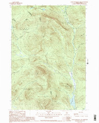
 1990 Lincoln Pond1990 Print · USGSThe North Woods of Oxford County are captured here in the late twentieth century, showing the wild river systems and timber lands before modern shifts. Researchers can trace remote sites like Bosebuck Camp, the falls at Big Falls, and the shoreline of Aziscohos Lake.2 unique versions available
 - 1990 Map of Big Lake
 1990 Big Lake1990 Print · USGSThe Indian Twp Indian Reservation and surrounding plantations are shown in detail during the late twentieth century. Researchers can locate the Peter Dana Point settlement, the Cem, and remote landings like Greenlaw Chopping Landing.
 - 1990 Map of Clifford Lake
 1990 Clifford Lake1990 Print · USGSWashington County, Maine, in the late twentieth century is a landscape of expansive waters and ridges. Genealogists and outdoorsmen can trace the shores of Clifford Lake and locate specific sites like Carloe Pond, Love Ridge, and the Plantation No 21 border.
 - 1990 Map of Little Kennebago Lake
 1990 Little Kennebago Lake1990 Print · USGSThe Maine-Quebec borderlands are captured here in the late twentieth century, showing the remote township system and high-country divides. Trace the rugged terrain of the White Cap Divide and search for landmarks like Little Kennebago Lake and Snow Mountain.2 unique versions available
 - 1990 Map of Northwest Pond
 1990 Northwest Pond1990 Print · USGSThe Maine-Quebec borderlands appear in high detail during the 1990s, revealing a landscape of high summits and remote glacial basins. Researchers can trace the international boundary line past Mont Gosford and locate historical landmarks like Massachusetts Bog and Seven Ponds.
 - 1990 Map of Louise Mountain
 1990 Louise Mountain1990 Print · USGSThe international boundary between Maine and Quebec is captured here in the late twentieth century, showing the remote border crossing at Coburn Gore. Researchers can trace the timber-based economy through labels like Scierie and locate historic points around Arnold Pond and Lac aux Araignées.
 - 1990 Map of Wesley
 1990 Wesley1990 Print · USGSWashington County’s timber and lake country is captured here during the late twentieth century. Genealogists and researchers can trace local landmarks like the Wesley Fire Tower, the small settlement at The Pines, and family-named waters such as Dudley Brook.
 - 1990 Map of Kennebago
 1990 Kennebago1990 Print · USGSNorthwestern Maine's timberlands and remote waters are captured here in the 1990s as they transitioned into the modern era. You can trace the rugged network of logging roads and fly-fishing waters near Grants Camps, Kennebago Lake, and the former Moochers Home (Site).
 - 1990 Map of Twin Peaks
 1990 Twin Peaks1990 Print · USGSThe Maine-Quebec borderlands in the early 1990s reveal a landscape of deep timber and remote watersheds within Oxford County. Researchers can trace the rugged drainage of the Magalloway River and locate isolated features like Twin Peaks, Abbie Pond, and scattered Gravel Pits.
 - 1990 Map of Dark Cove Mountain
 1990 Dark Cove Mountain1990 Print · USGSThe interconnected lakes of Washington County are shown in great detail during the late twentieth century, before the digital age reshaped backcountry navigation. Trace historical water routes and portages including Dennison Portage, Dobsis Dam, and the landing at Elsemore Landing.
 - 1990 Map of Princeton
 1990 Princeton1990 Print · USGSThe interconnected waterways of Washington County are captured here in the late twentieth century, centered on the lakeside town of Princeton. Researchers can trace old property lines and landmarks from Pocomoonshine Mountain to the Indian Twp Indian Reservation.
 - 1990 Map of Peaked Mountain Pond
 1990 Peaked Mountain Pond1990 Print · USGSWashington County, Maine, is shown in the early 1990s as a landscape of winding rivers and remote timberlands. Researchers can trace the path of the Machias River to find landmarks like Holmes Falls, Mattimo Place, and The Oxbow.
 - 1990 Map of Monroe Lake
 1990 Monroe Lake1990 Print · USGSWashington County’s interior waterways are captured here in the late twentieth century, showing a remote landscape of interconnected lakes and timberlands. Researchers can trace the flow of the Machias River through Second Machias Lake and locate specific features like Hay Meadows and Getchel Mountain.
 - 1990 Map of Fletcher Peak
 1990 Fletcher Peak1990 Print · USGSWashington County’s interior lake country is shown in the early nineties, characterized by high timbered peaks and isolated waters. Researchers can trace land divisions and landmark elevations like Fletcher Peak, the Lookout Tower, and Third Machias Lake.
 - 1990 Map of Tug Mountain
 1990 Tug Mountain1990 Print · USGSWashington County’s interior timberlands were largely unorganized territory in the late twentieth century. You can trace the hydrology of the Machias River while locating landmarks like Canaan Dam, Tug Mountain, and Kerosene Pond.
 - 1990 Map of Crawford Lake
 1990 Crawford Lake1990 Print · USGSCrawford and the surrounding Down East timberlands are captured here in the 1980s, showcasing a landscape of vast lakes and interconnected streams. Researchers can trace the water-bound borders of Plantation No 21 or locate local landmarks like Great Pine Point and the Gravel Pit.
 - 1990 Map of Parmachenee Lake
 1990 Parmachenee Lake1990 Print · USGSNear the Canadian border in the 1990s, this Maine backcountry remains a landscape of unorganized townships and high peaks. Genealogists and local historians can trace the drainages of the Magalloway River and locate remote landmarks like Little Boy Falls, Indian Cove, and Cupsuptic Mountain.2 unique versions available
 - 1990 Map of Peaked Mountain
 1990 Peaked Mountain1990 Print · USGSThe Maine North Woods in the early nineties reveal a landscape of vast water networks and timber ridges across Washington and Hancock counties. Researchers can trace the drainage of Lower Cranberry Lake and locate landforms like Peaked Mountain and Tibbetts Ridge.
 - 1990 Map of Grand Lake Stream
 1990 Grand Lake Stream1990 Print · USGSMaine's Washington County backcountry is captured here in the late twentieth century, centered on the historic timber and fishing hub at the outlet of West Grand Lake. Researchers can trace the grounds of the Grand Lake Stream State Fish Hatchery and numerous landmarks like Wabassus Mountain and Jumbo Landing.
 - 1993 Map of Van Buren
 1993 Van Buren1993 Print · USGSThe northern reaches of Aroostook Co are captured here in the early nineties, showing the interface between Maine and New Brunswick. Researchers can trace the riverfront development of Van Buren or locate the sprawling footprint of Loring Air Force Base near Hamlin.
 - 1993 Map of Lac Etchemin
 1993 Lac Etchemin1993 Print · USGSThe borderlands of Maine and Quebec in the 1990s are defined here by the international boundary cutting through dense timberlands and the Beauce valley. Researchers can trace the Port of Entry near the Saint John River Southwest Branch and explore the layouts of Beauceville and Lac-Etchemin.
Showing maps 1-25
Top cities of Maine
- Portland historical maps
- Lewiston historical maps
- Bangor historical maps
- South Portland historical maps
- Auburn historical maps
- Biddeford historical maps
See more
Top counties of Maine
- Cumberland County historical maps
- York County historical maps
- Penobscot County historical maps
- Kennebec County historical maps
- Androscoggin County historical maps
- County historical maps
See more
Frequently asked questions
- What are the different types of historical maps available for Maine?
- What is the oldest map of Maine?
- Where can I purchase historical maps of Maine for my home or office?
- Where can I download high-res historical maps of Maine?
- Are there historical topographic maps available for Maine?
- Is there historical aerial imagery available for Maine?
- Where are historical maps of Maine sourced from?