1930s Maps of Maine
Explore 101 historic maps of Maine from the 1930s. These maps offer a rare glimpse into what life looked like during the 1930s — showing old roads, neighborhoods, homes, and landmarks that have changed or disappeared over time.
Whether you're researching your family's past, planning a metal detecting trip, or studying how Maine's landscape evolved across the 1930s, these high-resolution maps are a powerful tool for exploring the history of this region.
- Focus on a specific era: All maps on this page are from the 1930s, giving you a focused view of this time period.
- See what’s changed: Compare century-old streets, trails, and buildings to today's modern landscape using overlays and satellite layers.
- Research with precision: Use these maps for genealogy, historical research, land use analysis, or educational projects.
- View, download, or print: Maps are fully viewable online in high resolution, and can be downloaded or printed for your own records.
Start exploring Maine's history through authentic maps from the 1930s. This is your window into the past.
Maine maps
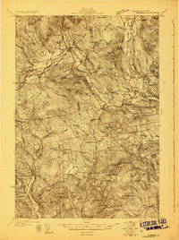
(101)- 1930 Map of Vanceboro
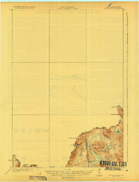
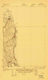 1930 Vanceboro1930 Print · USGSThe Maine and New Brunswick border comes alive in 1930, centering on the rail hub of Vanceboro and the St Croix River. Trace early 20th-century landmarks like the Cold Water Tavern, Camp Solitaire, and the intricate river rapids at Pork Rips.2 unique versions available
 - 1930 Map of Moosehead Lake
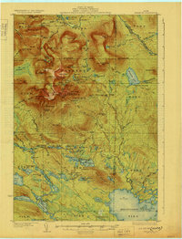
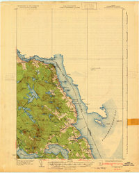
 1930 Moosehead Lake1930 Print · USGSMoosehead Lake in the early twentieth century was a landscape of remote rail junctions and lakeside settlements. Trace the old routes of the Maine Central Railroad to Rockwood or locate the Masterman School near the shores of North Bay.
 - 1930 Map of Tunk Lake
 1930 Tunk Lake1930 Print · USGSHancock County was a landscape of timber and tide in the early 1930s, where the Maine Central rail line linked small coastal villages to the deep woods. Genealogists and historians can trace old homesteads in Donnells, rural education at Tunk Lake Sch, and the locations of sporting retreats like the Wichyup Club.
 - 1930 Map of Rumford
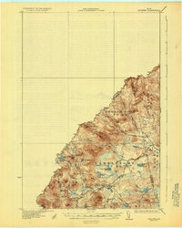
 1930 Rumford1930 Print · USGSRumford and the Androscoggin River valley are shown here just before the Great Depression, highlighting a bustling landscape of rail and industry. Genealogists and historians can trace local families through many district schools like Woodrow Sch and landmarks like Stockbridge Cem or Rumford Falls.5 unique versions available
 - 1930 Map of Katahdin
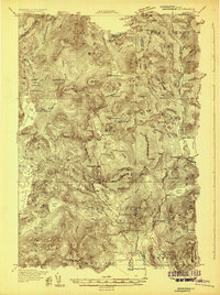
 1930 Katahdin1930 Print · USGSBackcountry Maine in the late 1920s offered a rugged landscape of newly surveyed trails and remote outposts. You can trace the early paths to Mount Katahdin and locate historic sites like Sewell Camp, Katahdin Lake Camp, and New City.6 unique versions available
 - 1930 Map of Pittsfield
 1930 Pittsfield1930 Print · USGSSomerset County in the early thirties reveals a network of farming hamlets and lakeside communities connected by rail and river. Genealogists can trace family names through landmarks like Todds Corner West Ripley PO, Nutter Cemetery, and Town Farm Sch.
 - 1930 Map of Greenlaw
 1930 Greenlaw1930 Print · USGSAroostook County was a hub of timber and rail activity in the early thirties, defined by remote camps and a developing backcountry road network. Genealogists and historians can trace old routes like the Old Military Road and locate sites such as Seven Mile Camp and Greenlaw Crossing.5 unique versions available
 - 1930 Map of Sandy Bay
 1930 Sandy Bay1930 Print · USGSUpper Somerset County at the Canadian border comes into focus in this late-1920s survey. Researchers can trace isolated wilderness outposts like Hilton Farm or follow the South Branch Penobscot River past South Branch Camp.5 unique versions available
 - 1930 Map of Allagash
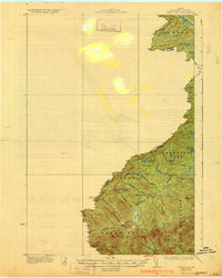
 1930 Allagash1930 Print · USGSThe northern Maine frontier at the turn of the 1930s was a landscape of remote river settlements and deep woods. Genealogists and historians can trace family locations along the St John River at Dickey, and find community landmarks like St Paul Ch and Henderson Sch.4 unique versions available
 - 1930 Map of Fort Fairfield
 1930 Fort Fairfield1930 Print · USGSThe international border of Aroostook County comes into focus in the 1930s, showing a landscape of rail-driven agriculture and rural school districts. Genealogists and historians can trace family-named landmarks like Cote Corner, Noyes Mill, and the Riverside Cemetery.
 - 1930 Map of Kingfield
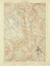
 1930 Kingfield1930 Print · USGSThe Kingfield region and the western Maine highlands are captured here in the early 1930s. Genealogists can locate family homesteads near numerous district schools like Guild Sch and Hardy Sch, or trace the old roads through New Vineyard and Strong.4 unique versions available
 - 1930 Map of St Francis
 1930 St Francis1930 Print · USGSThe Maine-Canada borderland comes alive in the early thirties as a hub of rail-and-river activity along the St John River. Genealogists and researchers can trace family lands near St Francis, local schoolhouses like Harding Sch, and logging sites like Saucier Camp.5 unique versions available
 - 1930 Map of Milan, 1952 Print
 1930 Milan1952 Print · USGSThe upper Androscoggin River valley is captured here in the early thirties, showing a rugged landscape of timber ridges and river-fed settlements. Genealogists can locate several local schools such as Jewett Sch and the rail-side village of Milan.3 unique versions available
 - 1930 Map of Errol, 1955 Print
 1930 Errol1955 Print · USGSThe timberlands along the New Hampshire and Maine border come alive in the 1930s, centered on the river networks that fueled the region. Genealogists and historians can trace remote outposts like Wilsons Mills, the Magalloway Sch, and industrial markers like Errol Dam.5 unique versions available
 - 1931 Map of Cupsuptic
 1931 Cupsuptic1931 Print · USGSOxford County's rugged northern interior comes to life in this early 1930s survey of the Maine woods. Trace the network of remote outposts and waterways that defined the region, from the Parmachenee Club and Riverside Camp to the waters of Cupsuptic Lake.5 unique versions available
 - 1931 Map of Square Lake
 1931 Square Lake1931 Print · USGSAroostook County's lake country in the early 1930s shows a landscape of timber camps and small rural settlements. Genealogists and historians can trace schools like Guerrette Sch and Thomas Sch or locate family-named landmarks like Ouellette and Yerxa Camp.4 unique versions available
 - 1931 Map of Fish River Lake
 1931 Fish River Lake1931 Print · USGSAroostook County was a hub of remote milling and sporting life in the early 1930s. Genealogists and historians can locate specific sites like Wheelock Mill, Blanchards Depot Camp, and the Fire Tower monitoring the timberlands.4 unique versions available
 - 1931 Map of Springfield
 1931 Springfield1931 Print · USGSPenobscot and Washington counties in the early 1930s reveal a landscape of ridges, bogs, and scattered timber camps. Genealogists can trace early rural life through features like Poplar Tavern Camp, the Dill Ridge Fire Tower, and numerous district schools like Cole Sch.4 unique versions available
 - 1931 Map of Dead River
 1931 Dead River1931 Print · USGSSomerset and Franklin counties in the mid-1920s show a landscape of remote plantations and traditional woodsman outposts. Genealogists and historians can trace localized landmarks like the Dead River School, the East Carry (Carry Pond PO) Pond, and Joe Farm.
 - 1931 Map of Stetson
 1931 Stetson1931 Print · USGSPenobscot County townships like Stetson and Exeter were thriving rural communities in the early thirties before modern school consolidation. Genealogists can locate family homesteads near numerous local landmarks like the Holy Rollers Sch, Exeter Fairgrounds, and Damascus Sta.
 - 1931 Map of Ashland
 1931 Ashland1931 Print · USGSAroostook County logging and rail life are detailed here in the early 1930s, centered on the Ashland and Sheridan settlements. Researchers can trace rural school districts from McClellan Sch to Garfield Sch or locate industrial sites like Newlands Mill and the Squapan Dam.
 - 1931 Map of Skinner
 1931 Skinner1931 Print · USGSThe Maine-Quebec borderlands in the late 1920s reveal a landscape of remote rail outposts and logging woods. Trace the path of the Canadian Pacific through Lowelltown, find Hogans Camp, and explore the headwaters of the Moose River.3 unique versions available
 - 1931 Map of Robbinston
 1931 Robbinston1931 Print · USGSThe Maine coast near Robbinston and the Canadian border is captured here during the interwar years as a landscape of maritime navigation and rural communities. Genealogists can trace family landmarks and local schools like Bog Brook Sch, Shore Sch, and the riverside village of Red Beach.4 unique versions available
 - 1931 Map of Mooseleuk Lake
 1931 Mooseleuk Lake1931 Print · USGSThe Aroostook and Piscataquis county borderlands are shown here in the early thirties as a vast expanse of timber and water. Trace the locations of remote outposts like Big Machias Lake Camps and the Great Northern Dam.2 unique versions available
 - 1931 Map of Moose Bog
 1931 Moose Bog1931 Print · USGSThe Maine and New Hampshire borderlands are captured here in the early thirties, showing a remote wilderness of high peaks and river headwaters. Genealogists and historians can trace family-named landmarks like Bowman Farm, Bowman Hill, and the secluded waters of Moose Bog.5 unique versions available
Showing maps 1-25 of 101
Top cities of Maine
- Portland historical maps
- Lewiston historical maps
- Bangor historical maps
- South Portland historical maps
- Auburn historical maps
- Biddeford historical maps
See more
Top counties of Maine
- Cumberland County historical maps
- York County historical maps
- Penobscot County historical maps
- Kennebec County historical maps
- Androscoggin County historical maps
- County historical maps
See more
Frequently asked questions
- What are the different types of historical maps available for Maine?
- What is the oldest map of Maine?
- Where can I purchase historical maps of Maine for my home or office?
- Where can I download high-res historical maps of Maine?
- Are there historical topographic maps available for Maine?
- Is there historical aerial imagery available for Maine?
- Where are historical maps of Maine sourced from?