2000-2009 Maps of Maine
Explore 13 historic maps of Maine from 2000-2009. These maps offer a rare glimpse into what life looked like during the 2000s — showing old roads, neighborhoods, homes, and landmarks that have changed or disappeared over time.
Whether you're researching your family's past, planning a metal detecting trip, or studying how Maine's landscape evolved across the 2000s, these high-resolution maps are a powerful tool for exploring the history of this region.
- Focus on a specific era: All maps on this page are from the 2000s, giving you a focused view of this time period.
- See what’s changed: Compare century-old streets, trails, and buildings to today's modern landscape using overlays and satellite layers.
- Research with precision: Use these maps for genealogy, historical research, land use analysis, or educational projects.
- View, download, or print: Maps are fully viewable online in high resolution, and can be downloaded or printed for your own records.
Start exploring Maine's history through authentic maps from the 2000s. This is your window into the past.
Maine maps
- 2000 Map of Camden, 2001 Print
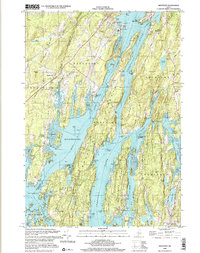
 2000 Camden2001 Print · USGSThe Maine coast near Camden and Rockport is shown here at the start of the new millennium, balancing deep-water harbors with high granite peaks. Researchers can locate family plots at Oak Hill Cem or trace the early paths of the Spring Brook Trail and Mount Battie observatory.
 - 2000 Map of Westport, 2001 Print
 2000 Westport2001 Print · USGSCoastal Lincoln County at the turn of the millennium reveals a landscape of deep tidal rivers and historic island settlements. Genealogists and local historians can trace family landmarks and rural sites like Doggett Castle, Grover Cem, and the old Westport Ch.
 - 2000 Map of Phippsburg, 2001 Print
 2000 Phippsburg2001 Print · USGSThe Kennebec River meets the Atlantic here as the twenty-first century begins, showcasing a coastline shaped by maritime history and military defense. Genealogists and historians can locate the Old Mica Mine, the Sebasco Sch, and landmark sites like the Fort Popham Lighthouse.
 - 2000 Map of Winthrop, 2001 Print
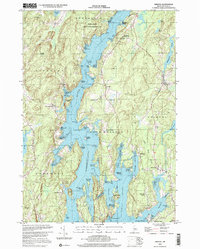
 2000 Winthrop2001 Print · USGSMaine's lake country at the turn of the millennium shows a landscape defined by deep-water ponds and small lakeside villages. Genealogists can locate family burial sites like Whistler Cem and Benson Cem, or trace landmarks at Tallwood and Winthrop Center.
 - 2000 Map of Lincolnville, 2001 Print
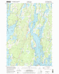
 2000 Lincolnville2001 Print · USGSMid-coast Maine at the turn of the millennium retains its traditional network of crossroads settlements and coastal landmarks. Genealogists can locate family burial grounds like Union Cem and trace the area's rural development through points like Slab City and Grange Corner.
 - 2000 Map of Bridgton, 2001 Print
 2000 Bridgton2001 Print · USGSThe Bridgton and Harrison area at the start of the new millennium is defined by its iconic lakes and deep-rooted summer camp culture. Researchers can locate numerous family burial sites like Finnish Cem and Trafton Cem or trace the early development of Sandy Creek and North Bridgton.
 - 2000 Map of Vinalhaven, 2001 Print
 2000 Vinalhaven2001 Print · USGSVinalhaven Island at the turn of the millennium retains the character of its granite-quarrying and maritime past. Local historians can trace family plots at Cummins Cem and explore industrial remains at Lawson Quarry Pond or Booth Quarry Pond.
 - 2000 Map of Norway, 2001 Print
 2000 Norway2001 Print · USGSOxford County at the turn of the millennium shows the enduring connection between New England towns and their waterways. Researchers can locate family landmarks like Otisfield Gore Cem, trace the banks of the Crooked River, or find old school sites like Fox Sch.
 - 2000 Map of Damariscotta, 2001 Print
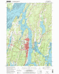
 2000 Damariscotta2001 Print · USGSThe mid-coast Maine landscape at the millennium shows a timeless network of river towns and tidal estuaries. Genealogists can trace family sites from Head Tide to Damariscotta Mills, including Pine Knoll Cem and the historic St Patricks Ch.
 - 2000 Map of Bath, 2001 Print
 2000 Bath2001 Print · USGSThe shipbuilding center of Bath and the surrounding river reaches of Sagadahoc County are documented here at the turn of the millennium. Researchers can trace historic waterfront landmarks like the Marine Mus, Ferry Slips, and the Doubling Point Light.
 - 2000 Map of Old Speck Mountain, 2001 Print
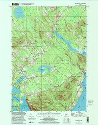
 2000 Old Speck Mountain2001 Print · USGSOxford County at the turn of the millennium is captured here in this survey of the northern Mahoosucs. Hikers and historians can trace the Appalachian Trail through Grafton Notch State Park to landmarks like Screw Auger Falls and the remote outpost at Ketchum.
 - 2000 Map of Bristol, 2001 Print
 2000 Bristol2001 Print · USGSCoastal Lincoln County at the turn of the millennium shows a landscape of deep-water rivers and historic meetinghouses. Researchers can trace land ownership and community roots near the Old Walpole Meetinghouse, West Bristol Cem, and the village of Bristol.
 - 2000 Map of Readfield, 2001 Print
 2000 Readfield2001 Print · USGSReadfield and Kents Hill sit at the heart of this central Maine lake district at the turn of the millennium. Genealogists can locate numerous family burial sites like Philbrick Cem and Marston Cem or trace the early settlement at Wings Mills.
End of results
Showing maps 1-13
Top cities of Maine
- Portland historical maps
- Lewiston historical maps
- Bangor historical maps
- South Portland historical maps
- Auburn historical maps
- Biddeford historical maps
See more
Top counties of Maine
- Cumberland County historical maps
- York County historical maps
- Penobscot County historical maps
- Kennebec County historical maps
- Androscoggin County historical maps
- County historical maps
See more
Frequently asked questions
- What are the different types of historical maps available for Maine?
- What is the oldest map of Maine?
- Where can I purchase historical maps of Maine for my home or office?
- Where can I download high-res historical maps of Maine?
- Are there historical topographic maps available for Maine?
- Is there historical aerial imagery available for Maine?
- Where are historical maps of Maine sourced from?