1920s Maps of Minnesota
Explore 9 historic maps of Minnesota from the 1920s. These maps offer a rare glimpse into what life looked like during the 1920s — showing old roads, neighborhoods, homes, and landmarks that have changed or disappeared over time.
Whether you're researching your family's past, planning a metal detecting trip, or studying how Minnesota's landscape evolved across the 1920s, these high-resolution maps are a powerful tool for exploring the history of this region.
- Focus on a specific era: All maps on this page are from the 1920s, giving you a focused view of this time period.
- See what’s changed: Compare century-old streets, trails, and buildings to today's modern landscape using overlays and satellite layers.
- Research with precision: Use these maps for genealogy, historical research, land use analysis, or educational projects.
- View, download, or print: Maps are fully viewable online in high resolution, and can be downloaded or printed for your own records.
Start exploring Minnesota's history through authentic maps from the 1920s. This is your window into the past.
Minnesota maps
(9)- 1920 Map of Trout Lake
 1920 Trout Lake1920 Print · USGSItasca County's industrial heartland is documented here just as the mining boom transformed the landscape. Trace the early streets and rail spurs of Coleraine, Bovey, and Taconite, or locate lost sites like the U.S.B.M. Dam and Arcturus.
 - 1920 Map of Buena Vista, 1944 Print
 1920 Buena Vista1944 Print · USGSBeltrami County at the opening of the 1920s reveals a landscape of timbered townships and lakeside outposts tied together by early rail and trail. Genealogists and researchers can locate old communities like Puposky, Lavinia, and Buena Vista, or trace the Indian Reservation Boundary and Turtle River Station.
 - 1921 Map of Baudette
 1921 Baudette1921 Print · USGSBaudette and Spooner anchor this borderland survey during the early 1920s, showing a landscape defined by timber and drainage. Researchers can trace early railroad history along the Canadian Northern or locate rural landmarks like Pitt and Wabanica Creek.2 unique versions available
 - 1924 Map of Ada, 1944 Print
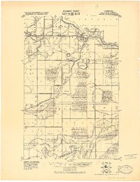
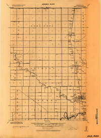 1924 Ada1944 Print · USGSNorman County agricultural life is captured here in the mid-1920s, centered on the railroad towns of the Red River Valley. Researchers can trace the importance of the Great Northern rail line and identify specific local landmarks like the Ada Courthouse Tower, Lockhart Elevator, and the Fair Grounds.
 - 1924 Map of Bridgie, 1944 Print
 1924 Bridgie1944 Print · USGSNorthern Minnesota's woods and wetlands are captured here in the mid-1920s as the rail lines and early settlements began to formalize the landscape. Researchers can trace the path of the Minnesota International through vanished rail stops and small towns like Orth, Funkley, and Bridgie.
 - 1926 Map of Stoddard
 1926 Stoddard1926 Print · USGSUpper Mississippi river life and ridge-top farming meet in the mid-1920s along the Wisconsin-Minnesota border. Researchers can trace the complex river channels near Stoddard or find family roots at rural landmarks like Evening Star School and Romance.2 unique versions available
 - 1927 Map of La Crosse, 1960 Print
 1927 La Crosse1960 Print · USGSLa Crosse and the Mississippi riverfront are captured in the 1920s as rail transit reached its peak. Genealogists can trace family names across dozens of rural school districts like Adams Valley Sch or locate landmarks such as Grand Dad Bluff and the County Asylum.
 - 1929 Map of Fountain City
 1929 Fountain City1929 Print · USGSIn the late twenties, the Mississippi River bluffs near Fountain City were defined by a steep landscape of narrow valleys and ridge-top farms. Researchers can trace dozens of rural school sites like Buffalo Ridge Sch and Oak Grove Sch among the winding tracks of State Hwy 35.2 unique versions available
 - 1929 Map of Galesville
 1929 Galesville1929 Print · USGSWisconsin's coulee country and the Mississippi riverfront are captured here in the mid-twenties, showing a landscape of bluff-top farms and river towns. Genealogists can locate family landmarks like Butman Corners, Norway Valley Ch, and numerous rural schools including Wayside Sch.2 unique versions available
End of results
Showing maps 1-9 of 9
Top cities of Minnesota
- Minneapolis historical maps
- Saint Paul historical maps
- Rochester historical maps
- Duluth historical maps
- Bloomington historical maps
- Brooklyn Park historical maps
See more
Top counties of Minnesota
- Hennepin County historical maps
- Ramsey County historical maps
- Dakota County historical maps
- Washington County historical maps
- Saint Louis County historical maps
- Stearns County historical maps
See more
Frequently asked questions
- What are the different types of historical maps available for Minnesota?
- What is the oldest map of Minnesota?
- Where can I purchase historical maps of Minnesota for my home or office?
- Where can I download high-res historical maps of Minnesota?
- Are there historical topographic maps available for Minnesota?
- Is there historical aerial imagery available for Minnesota?
- Where are historical maps of Minnesota sourced from?