1930s Maps of Minnesota
Explore 23 historic maps of Minnesota from the 1930s. These maps offer a rare glimpse into what life looked like during the 1930s — showing old roads, neighborhoods, homes, and landmarks that have changed or disappeared over time.
Whether you're researching your family's past, planning a metal detecting trip, or studying how Minnesota's landscape evolved across the 1930s, these high-resolution maps are a powerful tool for exploring the history of this region.
- Focus on a specific era: All maps on this page are from the 1930s, giving you a focused view of this time period.
- See what’s changed: Compare century-old streets, trails, and buildings to today's modern landscape using overlays and satellite layers.
- Research with precision: Use these maps for genealogy, historical research, land use analysis, or educational projects.
- View, download, or print: Maps are fully viewable online in high resolution, and can be downloaded or printed for your own records.
Start exploring Minnesota's history through authentic maps from the 1930s. This is your window into the past.
Minnesota maps
(23)- 1930 Map of Juneberry
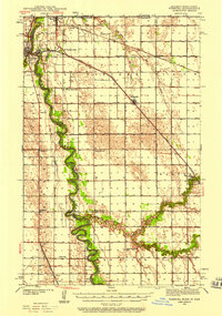
 1930 Juneberry1930 Print · USGSThe northern Minnesota borderlands come into focus at the start of the 1930s, showing the early efforts to drain the vast marshy plains. Genealogists and local historians can locate rural schoolhouses like Oak Point Sch and family-named features such as Johnson Sch and Moose Point.
 - 1930 Map of La Crescent
 1930 La Crescent1930 Print · USGSAs the Mississippi and Black Rivers met in the late twenties, this survey captured a world of river-bottom sloughs and busy rail junctions. Genealogists can trace early homesteads and schools like Oak Grove Sch, while exploring the vanished river paths of Bullet Chute and New Amsterdam.3 unique versions available
 - 1930 Map of La Crosse
 1930 La Crosse1930 Print · USGSThe riverfront and blufflands of western Wisconsin are captured here as the Great Depression began, showing a landscape defined by rail transit and coulee farming. Researchers can find numerous rural landmarks, from the County Asylum to small district sites like Maple Shade Sch and Barre Mills.3 unique versions available
 - 1932 Map of Cochrane
 1932 Cochrane1932 Print · USGSThe Mississippi River valley in the early thirties shows a intricate network of islands and sloughs tucked beneath high bluffs. Trace the historical footprints of Buffalo City, locate rural schoolhouses like Oak Valley Sch, and follow the Chicago Burlington and Quincy rail line.
 - 1932 Map of Juneberry
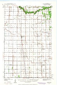
 1932 Juneberry1932 Print · USGSThe northern Minnesota borderlands and Roseau County wetlands are captured here in the early thirties, just as large-scale drainage projects transformed the terrain. Researchers can trace the rural school system through Oak Point Sch and Johnson Sch, or locate the settlement of Caribou near the Roseau River.2 unique versions available
 - 1932 Map of Wabasha
 1932 Wabasha1932 Print · USGSThe Mississippi River valley near the Chippewa delta was a thriving hub of rail and river commerce in the early thirties. Genealogists can trace early homesteads and community hubs through landmarks like Hicks Valley Sch, Stockholm, and the river crossing at Nelson.2 unique versions available
 - 1932 Map of Alma
 1932 Alma1932 Print · USGSThe river valleys and high ridges of Buffalo County are captured here in the early 1930s, showing a landscape of small farms and rural schoolhouses. Genealogists and local historians can trace the foundations of this community through dozen of school sites like Mill Creek Sch and Cascade Sch, alongside the U S Game Refuge and the rail lines through Alma.2 unique versions available
 - 1933 Map of Ely, 1961 Print
 1933 Ely1961 Print · USGSThe iron-rich Vermilion Range comes alive in the early 1930s, showing the intersection of heavy industry and the Northwoods wilderness. Genealogists and historians can trace the foundations of Ely and Winton, including the Pioneer Mines and the Halfway CCC Camp.
 - 1934 Map of Grand Forks
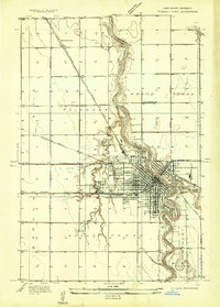 1934 Grand Forks1934 Print · USGSGrand Forks and East Grand Forks appear as a burgeoning rail and river hub in the mid-1930s. Researchers can trace the early footprint of the University of North Dakota or locate local landmarks like the State Elevator and Mill and Schumeier Switch.
 - 1934 Map of Grand Forks
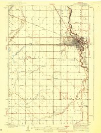
 1934 Grand Forks1934 Print · USGSThe Red River Valley in the mid-1930s shows a landscape of growing river towns and a dense network of rural school districts. Genealogists can trace family connections to the UNIVERSITY OF NORTH DAKOTA, West Walle Ch, or early outposts like Merrifield and Schurmeier.2 unique versions available
 - 1934 Map of Winona, 1955 Print
 1934 Winona1955 Print · USGSThe Mississippi River valley in the mid-1930s reveals a complex network of rail lines and river engineering. Researchers can trace the grounds of St Marys College, find rural schools like Meyers Sch, and locate the early infrastructure of Lock and Dam No 5A.2 unique versions available
 - 1934 Map of Plainview, 1960 Print
 1934 Plainview1960 Print · USGSWabasha and Winona Counties are shown in the mid-1930s as the railroad era connects prairie towns to the dramatic river bluffs. Genealogists can trace rural homesteads through a dense network of district schools like Fisher Hill Sch and historic grounds such as the Wabasha County Fair Grounds.
 - 1934 Map of Cochrane, 1968 Print
 1934 Cochrane1968 Print · USGSThe Mississippi River corridor and surrounding bluffs are captured here in the mid-1930s, documenting the riverside rail lines and upland farm communities. Genealogists can trace family landmarks like Young Cem, Mount Vernon Sch, and the Transient Relief Camp.
 - 1935 Map of Rochester
 1935 Rochester1935 Print · USGSSoutheastern Minnesota during the mid-thirties reveals a landscape of thriving river towns and dense rural school districts. Genealogists and historians can trace family roots through numerous country schools like Sch No 106 and cemeteries such as Pleasant Prairie Cem.
 - 1937 Map of Winona
 1937 Winona1937 Print · USGSIn the mid-thirties, the Mississippi River valley near Winona was a bustling network of rail yards and river channels. Genealogists and historians can trace the foundations of local communities through landmarks like St Marys College, the St Marys Cem, and vanished schoolhouses like Bohris Valley Sch.3 unique versions available
 - 1937 Map of Cochrane
 1937 Cochrane1937 Print · USGSThe Mississippi River bluffs during the late thirties show a region defined by river navigation and rural township life. Genealogists can trace family roots through numerous local landmarks like Hebron Ch, Mount Vernon Cem, and schools from Buffalo to Rollingstone.2 unique versions available
 - 1938 Map of Plainview
 1938 Plainview1938 Print · USGSSoutheastern Minnesota's driftless landscape was a patchwork of family farms and rural school districts in the late thirties. Genealogists and historians can trace the foundations of Plainview and Elba, and locate several burial grounds like Greenwood Cem and Fairwater Cem.2 unique versions available
 - 1938 Map of Grand Forks
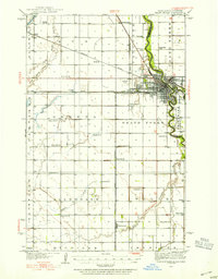
 1938 Grand Forks1938 Print · USGSGrand Forks and East Grand Forks appear as thriving rail hubs in the mid-1930s at the confluence of the Red and Red Lake Rivers. Researchers can trace rural school locations from School No 25 to School No 6 and identify landmarks like the Landing Field and Brenna Ch.3 unique versions available
 - 1939 Map of Rochester
 1939 Rochester1939 Print · USGSRochester and the Zumbro River valley are captured here in the mid-thirties, showcasing the city's early layout and the surrounding agrarian townships. Genealogists can trace family roots through dozens of named country schools and churches like South Troy Ch and Webster Sch.4 unique versions available
 - 1939 Map of Ely
 1939 Ely1939 Print · USGSEly and the surrounding Iron Range were dominated by heavy industry and woodland conservation in the years before the war. Genealogists and historians can locate specific sites like Pioneer Mines, the Halfway CCC Camp, and the White Iron Sch.3 unique versions available
 - 1939 Map of Drayton, 1954 Print
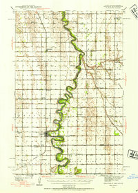 1939 Drayton1954 Print · USGSThe Red River valley at the onset of the Second World War shows a landscape defined by tight river bends and a thriving railroad economy. Genealogists and local historians can trace family locations near dozens of rural schools and churches like Daymon Sch, Tabitha Ch, and the settlement of Bowesmont.2 unique versions available
 - 1939 Map of Pembina, 1958 Print
 1939 Pembina1958 Print · USGSThe international border at the Red River Valley was a busy corridor of rail and river transit in the late 1930s. Genealogists can locate numerous rural schoolhouses like Fleece Sch and Joe River Sch, or trace the tracks of the Great Northern through St Vincent.3 unique versions available
 - 1939 Map of Kennedy, 1963 Print
 1939 Kennedy1963 Print · USGSUpper Minnesota prairie life is centered on the Great Northern railroad in the years before the war. Genealogists and local historians can trace family roots through numerous country schools and churches like McKinley Sch, Happy Corner, and Enok Ch.2 unique versions available
End of results
Showing maps 1-23 of 23
Top cities of Minnesota
- Minneapolis historical maps
- Saint Paul historical maps
- Rochester historical maps
- Duluth historical maps
- Bloomington historical maps
- Brooklyn Park historical maps
See more
Top counties of Minnesota
- Hennepin County historical maps
- Ramsey County historical maps
- Dakota County historical maps
- Washington County historical maps
- Saint Louis County historical maps
- Stearns County historical maps
See more
Frequently asked questions
- What are the different types of historical maps available for Minnesota?
- What is the oldest map of Minnesota?
- Where can I purchase historical maps of Minnesota for my home or office?
- Where can I download high-res historical maps of Minnesota?
- Are there historical topographic maps available for Minnesota?
- Is there historical aerial imagery available for Minnesota?
- Where are historical maps of Minnesota sourced from?