1990s Maps of Minnesota
Explore 142 historic maps of Minnesota from the 1990s. These maps offer a rare glimpse into what life looked like during the 1990s — showing old roads, neighborhoods, homes, and landmarks that have changed or disappeared over time.
Whether you're researching your family's past, planning a metal detecting trip, or studying how Minnesota's landscape evolved across the 1990s, these high-resolution maps are a powerful tool for exploring the history of this region.
- Focus on a specific era: All maps on this page are from the 1990s, giving you a focused view of this time period.
- See what’s changed: Compare century-old streets, trails, and buildings to today's modern landscape using overlays and satellite layers.
- Research with precision: Use these maps for genealogy, historical research, land use analysis, or educational projects.
- View, download, or print: Maps are fully viewable online in high resolution, and can be downloaded or printed for your own records.
Start exploring Minnesota's history through authentic maps from the 1990s. This is your window into the past.
Minnesota maps
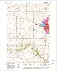
(142)- 1990 Map of La Crosse, 1991 Print
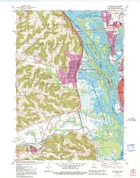
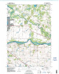
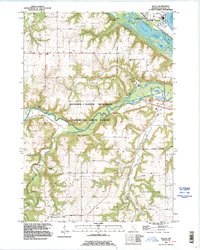
 1990 La Crosse1991 Print · USGSThe tri-state river valley at the end of the twentieth century shows a landscape defined by the Mississippi River and heavy rail. Trace the paths of the Soo Line and Burlington Northern through river towns like Brownsville and La Crescent.
 - 1990 Map of Outer Island, 1991 Print
 1990 Outer Island1991 Print · USGSThe northern Apostle Islands and the Lake Superior shoreline are captured here in the early 1990s. Researchers can trace remote maritime landmarks like the Outer Island Light and Devils Island or explore the coastal boundary of the Finland State Forest.
 - 1990 Map of Hastings, 1991 Print
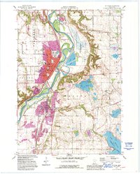
 1990 Hastings1991 Print · USGSThe river confluence at Hastings and Prescott is captured here in the final decade of the twentieth century, showing a landscape defined by the Mississippi River and St Croix River. Genealogists and historians can trace rail corridors like the Soo RR and find smaller settlements such as Miesville, Wacouta, and Diamond Bluff.
 - 1991 Map of New Ulm
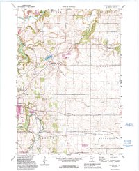
 1991 New Ulm1991 Print · USGSThe Minnesota River valley serves as the backbone for this late-century look at the agricultural heartland between New Ulm and Mankato. Researchers can trace the layout of traditional prairie towns like Sleepy Eye and Madelia or explore recreation sites at Fort Ridgely State Park.
 - 1991 Map of Mora
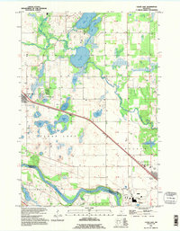
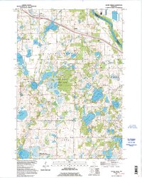
 1991 Mora1991 Print · USGSThe Rum River valley and central Minnesota lakelands are shown in great detail in the early 1990s. Genealogists and local historians can trace rural school locations, family cemeteries, and local landmarks like St. Marys Ch or the Municipal Airport in Mora.
 - 1991 Map of Anoka, 1992 Print
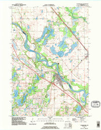
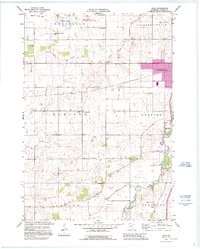
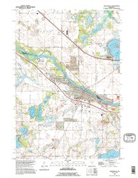
 1991 Anoka1992 Print · USGSThe northern Twin Cities suburbs and the upper Mississippi River valley are captured here in the early nineties during a period of rapid suburban expansion. Trace the rail corridors of the Burlington Northern Railroad or explore the boundaries of the Sherburne National Wildlife Refuge and Lake Maria State Park.
 - 1991 Map of La Crescent, 1995 Print
 1991 La Crescent1995 Print · USGSThe Mississippi River valley in the early 1990s reveals a intricate landscape of island settlements and wildlife refuges between Minnesota and Wisconsin. You can trace old railroad lines like the Soo Line and locate historic sites such as Crucifixion Cem and Summit Sch.
 - 1991 Map of Clearwater, 1995 Print
 1991 Clearwater1995 Print · USGSThe tri-county region of Central Minnesota is captured here during the 1990s, centered on the river-front growth of Clearwater and Clear Lake. Researchers can trace old family plots at St Luke Cem and St Marcus Cem or locate the numerous landings along the Mississippi River.
 - 1991 Map of Hinckley, 1995 Print
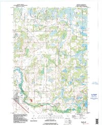
 1991 Hinckley1995 Print · USGSPine County in the early nineties shows a landscape shaped by the Grindstone River and the Burlington Northern railroad. Genealogists and researchers can locate landmarks like the State Fish Hatchery, the small village of Friesland, and the Municipal Airport.
 - 1991 Map of Becker, 1995 Print
 1991 Becker1995 Print · USGSCentral Minnesota's riverfront and marshlands are documented here in the early nineties, centered on the growing town of Becker. Genealogists and researchers can trace local family landmarks like Danish Cem or explore the wetlands of Sherburne National Wildlife Refuge.
 - 1991 Map of Big Lake, 1995 Print
 1991 Big Lake1995 Print · USGSSherburne and Wright counties meet along the Mississippi River in this early 1990s survey of central Minnesota. Genealogists and local historians can trace the lakeside developments of Big Lake and Monticello or locate rural landmarks like the Cem at Bailey.
 - 1991 Map of Clear Lake, 1995 Print
 1991 Clear Lake1995 Print · USGSSherburne County in the early nineties is a landscape of glacial lakes and river bends where the Mississippi River meets the rural prairie. Genealogists and local historians can trace the developments of Clear Lake and Becker or locate family sites near Briggs Lake and the Cem.
 - 1991 Map of Cannon City, 1995 Print
 1991 Cannon City1995 Print · USGSRice County's agricultural landscape is captured here in the early nineties, showing the convergence of the Cannon and Straight Rivers. Genealogists can locate rural school sites like Wide Awake Sch and small settlements including Prairieville and Ruskin.
 - 1991 Map of St Peter, 1995 Print
 1991 St Peter1995 Print · USGSSt Peter and the Minnesota River valley are shown here in the early nineties, capturing the city's growth alongside its deep historical roots. Genealogists and researchers can trace local family history through Elim Welsh Cem and Kasota Cem or locate the old quarries that built the region's economy.2 unique versions available
 - 1991 Map of Saco, 1995 Print
 1991 Saco1995 Print · USGSSteel County farmland in the early nineties reveals a transition from traditional rural townships to modern regional centers. Genealogists can locate family burial sites at Bohemian Cem and Crane Creek Cem or trace vanished district schools like School No 2116.
 - 1991 Map of Silver Creek, 1995 Print
 1991 Silver Creek1995 Print · USGSWright County’s lake-rich interior is captured here in the early nineties, showing a landscape defined by significant conservation and state park lands. Genealogists can locate rural burial grounds like Highland Cem or Lakeview Cem and trace old road networks through Hasty and Enfield.
 - 1991 Map of Welch, 1995 Print
 1991 Welch1995 Print · USGSGoodhue County in the early nineties reveals a landscape where the river valleys dictate the location of settlements and recreation. Genealogists can trace family footprints near Welch, Vasa, and Lundell, or locate landmarks like the Mt Carmel cemetery and Belle Creek.
 - 1991 Map of Lake Fremont, 1995 Print
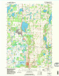 1991 Lake Fremont1995 Print · USGSSherburne County is shown here in the early nineties, a period of transition as the Elk River area expanded into its rural surroundings. Genealogists and local historians can trace burial sites at Livonia Cem and Whitney Cem or explore the shores of Lake Fremont.
 - 1991 Map of Waseca, 1995 Print
 1991 Waseca1995 Print · USGSWaseca and the surrounding farm townships are seen here in the early 1990s as the regional agricultural and educational landscape evolved. Genealogists and local historians can locate several historic burial sites like Iosco Cem and St Marys Cem, or trace the Chicago and North Western rail line through town.
 - 1991 Map of Monticello, 1995 Print
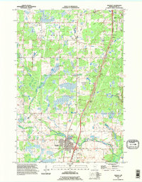
 1991 Monticello1995 Print · USGSThe Mississippi River corridor between Wright and Sherburne counties is documented here in the early nineties as lakeside communities grew. Trace family heritage at Riverside Cem and St Henrys Cem or explore the wetlands around Pelican Lake.
 - 1991 Map of Faribault, 1995 Print
 1991 Faribault1995 Print · USGSThe Rice County seat at the start of the nineties reveals a unique landscape of specialized institutions and riverfront industry. Genealogists can trace several regional burial sites like Maple Lawn Cemetery and locate historic campuses including the Minnesota Sch for the Deaf.
 - 1991 Map of Orrock, 1995 Print
 1991 Orrock1995 Print · USGSSherburne County is captured in the early nineties as a mosaic of protected wetlands and managed forests. Trace local family histories through Galbraith Cem and Svea Hill Cem, or explore the winding course of the St Francis River.
 - 1991 Map of St Michael, 1995 Print
 1991 St Michael1995 Print · USGSWright and Hennepin counties meet at the bend of the Crow River in the early nineties, showing a region transitioning from rural townships to growing suburban centers. Trace local history through landmarks like Berning Mill, St Michael Ch, and the numerous lakes such as Pelican Lake.
 - 1991 Map of Northfield, 1995 Print
 1991 Northfield1995 Print · USGSNorthfield and the Cannon River valley are seen here in the early nineties, a period of established academic and civic growth. Researchers can trace the sprawling grounds of St Olaf College and Carleton College, or locate rural landmarks like Little Prairie Ch and the hamlet of Waterford.
 - 1992 Map of Thief River Falls
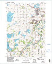
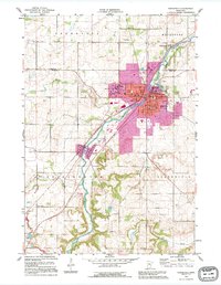
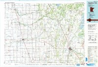 1992 Thief River Falls1992 Print · USGSThe Red River Valley's agricultural heartland is documented here in the early nineties, showing the vital rail and river networks of Marshall and Pennington counties. Researchers can trace family ties and vanished homesteads near St Hilaire, Strandquist, and the Agassiz National Wildlife Refuge.
Showing maps 1-25 of 142
Top cities of Minnesota
- Minneapolis historical maps
- Saint Paul historical maps
- Rochester historical maps
- Duluth historical maps
- Bloomington historical maps
- Brooklyn Park historical maps
See more
Top counties of Minnesota
- Hennepin County historical maps
- Ramsey County historical maps
- Dakota County historical maps
- Washington County historical maps
- Saint Louis County historical maps
- Stearns County historical maps
See more
Frequently asked questions
- What are the different types of historical maps available for Minnesota?
- What is the oldest map of Minnesota?
- Where can I purchase historical maps of Minnesota for my home or office?
- Where can I download high-res historical maps of Minnesota?
- Are there historical topographic maps available for Minnesota?
- Is there historical aerial imagery available for Minnesota?
- Where are historical maps of Minnesota sourced from?