1920s Maps of Oklahoma
Explore 6 historic maps of Oklahoma from the 1920s. These maps offer a rare glimpse into what life looked like during the 1920s — showing old roads, neighborhoods, homes, and landmarks that have changed or disappeared over time.
Whether you're researching your family's past, planning a metal detecting trip, or studying how Oklahoma's landscape evolved across the 1920s, these high-resolution maps are a powerful tool for exploring the history of this region.
- Focus on a specific era: All maps on this page are from the 1920s, giving you a focused view of this time period.
- See what’s changed: Compare century-old streets, trails, and buildings to today's modern landscape using overlays and satellite layers.
- Research with precision: Use these maps for genealogy, historical research, land use analysis, or educational projects.
- View, download, or print: Maps are fully viewable online in high resolution, and can be downloaded or printed for your own records.
Start exploring Oklahoma's history through authentic maps from the 1920s. This is your window into the past.
Oklahoma maps
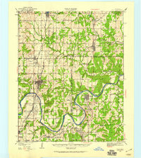
(6)- 1925 Map of Antlers
 1925 Antlers1925 Print · USGSSoutheastern Oklahoma's river valleys and rail lines are documented here in the years following statehood. Genealogists can trace family roots through numerous local landmarks like Armstrong Academy, the Asphalt Mine, and many rural sites like Nelson Chapel School.
 - 1925 Map of Norman NO 2
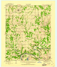
 1925 Norman NO 21925 Print · USGSNorman and the university grounds are pictured in the mid-twenties during a period of steady growth along the river bluffs. Genealogists can locate family-named landmarks and rural schoolhouses like White Mound School and Adair School.
 - 1929 Map of Yale, 1959 Print
 1929 Yale1959 Print · USGSOklahoma's oil and rail heartland comes into focus in the late 1920s as the petroleum industry reshapes the landscape of the former Indian Territory. Researchers can trace the extensive network of rural schools and industrial sites, from 35 Oil Tanks near Oilton to the many country schoolhouses like Lone Elm Sch and Bethel Sch.
 - 1929 Map of Ripley, 1959 Print
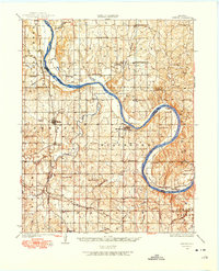
 1929 Ripley1959 Print · USGSEastern Oklahoma townships in Payne and Pawnee Counties appear here as they were in the late 1920s, structured by early rail lines and river bends. You can trace the community life of the era through sites like Ingalls Signet P O, the Rosenwald Sch, and the Atchison Topeka and Santa Fe tracks.
 - 1929 Map of Stroud, 1972 Print
 1929 Stroud1972 Print · USGSCentral Oklahoma is captured here in the late twenties, showing the intersection of early highway travel and deep-rooted rural communities. Researchers can trace historic schools and rail lines, including the Sac and Fox Sch, Paden, and the legendary Highway No 66.
 - 1929 Map of Skedee, 1975 Print
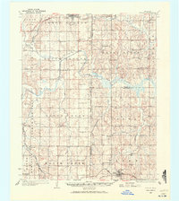
 1929 Skedee1975 Print · USGSNorth-central Oklahoma's river-and-rail landscape is captured here in the late 1920s, dominated by the looping current of the Arkansas River. Genealogists and historians can trace numerous rural schools and early infrastructure, from the East Bend Ferry to the Bug Creek Indian Camp.
End of results
Showing maps 1-6 of 6
Top cities of Oklahoma
- Oklahoma City historical maps
- Tulsa historical maps
- Norman historical maps
- Broken Arrow historical maps
- Lawton historical maps
- Edmond historical maps
See more
Top counties of Oklahoma
- Oklahoma County historical maps
- Cleveland County historical maps
- Canadian County historical maps
- Comanche County historical maps
- Rogers County historical maps
- Payne County historical maps
See more
Frequently asked questions
- What are the different types of historical maps available for Oklahoma?
- What is the oldest map of Oklahoma?
- Where can I purchase historical maps of Oklahoma for my home or office?
- Where can I download high-res historical maps of Oklahoma?
- Are there historical topographic maps available for Oklahoma?
- Is there historical aerial imagery available for Oklahoma?
- Where are historical maps of Oklahoma sourced from?