1930s Maps of Tennessee
Explore 584 historic maps of Tennessee from the 1930s. These maps offer a rare glimpse into what life looked like during the 1930s — showing old roads, neighborhoods, homes, and landmarks that have changed or disappeared over time.
Whether you're researching your family's past, planning a metal detecting trip, or studying how Tennessee's landscape evolved across the 1930s, these high-resolution maps are a powerful tool for exploring the history of this region.
- Focus on a specific era: All maps on this page are from the 1930s, giving you a focused view of this time period.
- See what’s changed: Compare century-old streets, trails, and buildings to today's modern landscape using overlays and satellite layers.
- Research with precision: Use these maps for genealogy, historical research, land use analysis, or educational projects.
- View, download, or print: Maps are fully viewable online in high resolution, and can be downloaded or printed for your own records.
Start exploring Tennessee's history through authentic maps from the 1930s. This is your window into the past.
Tennessee maps
(584)- 1930 Map of Middlesboro
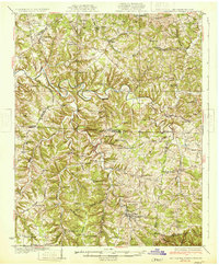
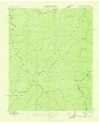
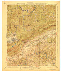 1930 Middlesboro1930 Print · USGSThe tri-state border region comes alive in the late 1920s, centered on the strategic mountain pass at Cumberland Gap. Genealogists and historians can trace family locations near Middlesboro, early campus sites at Lincoln Memorial University, and rural landmarks like Ellison Mill.4 unique versions available
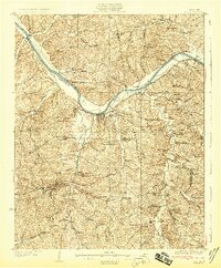
 - 1930 Map of White Bluff, 1953 Print
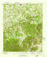
 1930 White Bluff1953 Print · USGSMiddle Tennessee in the 1930s is defined by the serpentine bends of the Harpeth River and the steam-era dominance of the Nashville Chattanooga and St Louis RR. Genealogists and historians can locate vanished country schools like Opossum Sch and trace early road networks including the Dickson Turnpike.
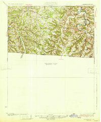
 - 1931 Map of Erin
 1931 Erin1931 Print · USGSThe Cumberland River corridor and the railroad hub of Erin define this landscape in the late 1920s. Genealogists can trace family footprints through dozens of rural schools and churches, from Blooming Grove Ch to the remote Cave Orchard Sch.
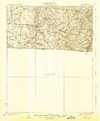
 - 1931 Map of Horseshoe Lake
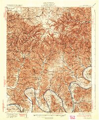
 1931 Horseshoe Lake1931 Print · USGSThe Mississippi Delta's shifting landscape is captured here in the early thirties, centered on the great oxbow of Horseshoe Lake. Genealogists and historians can trace family-named tracts like the Tucker Plantation and Seyppel Plantation, alongside rural landmarks like the Y M C A Camp and Robinsonville.
 - 1931 Map of Lafayette
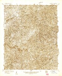
 1931 Lafayette1931 Print · USGSThe Kentucky and Tennessee borderlands in the late twenties were a network of tight-knit rural communities connected by winding river hollows. Genealogists and local historians can trace family roots through numerous small landmarks like Austin Sch, Mt Zion Ch, and the settlement of Holland.2 unique versions available
 - 1931 Map of Adolphus
 1931 Adolphus1931 Print · USGSThe Kentucky-Tennessee state line was a landscape of river fords and country schoolhouses during the late Prohibition era. Genealogists can trace family footprints through dozens of local landmarks like Old Mill Ford, McKendree Chapel, and Pinkle Cem.2 unique versions available
 - 1931 Map of Jericho
 1931 Jericho1931 Print · USGSThe Arkansas-Tennessee borderlands appear here in the early 1930s, defined by the winding Mississippi and its evolving islands. Genealogists and researchers can trace old river landings like Pecan Point, rail stops at Jericho, and the rural Mt Vernon Church.
 - 1931 Map of Red Boiling Springs
 1931 Red Boiling Springs1931 Print · USGSCrossing the state line during the late twenties, this survey captures a landscape of ridge-top schools and creek-side settlements. Genealogists can trace family footprints through numerous rural landmarks like Sadlers Chapel, Akersville, and Hermitage Springs PO.3 unique versions available
 - 1931 Map of Ridgetop, 1957 Print
 1931 Ridgetop1957 Print · USGSUpper Middle Tennessee in the early thirties reveals a landscape of ridge-top towns and deep hollows. Genealogists can trace family footprints through dozens of rural landmarks like St Michaels Ch, Gordons Store, and the old Ridgetop Sta.2 unique versions available
 - 1932 Map of Hagan
 1932 Hagan1932 Print · USGSThe rugged borderlands of Kentucky and Virginia come to life in this early 1930s survey of the high gaps and hollows. Researchers can locate remote mountain landmarks like Hensley Sch, Feepee Store, and the scattered cabins at Alva.3 unique versions available
 - 1932 Map of Hermitage
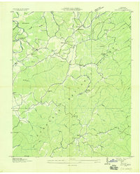
 1932 Hermitage1932 Print · USGSGreater Nashville and its rural eastern reaches come alive in the early 1930s, documenting the river-bend communities and pike roads before modern sprawl. Genealogists can trace family roots through dozens of local landmarks like Woodbine P O, Clover Bottom, and the Andrew Jackson Sch.3 unique versions available
 - 1932 Map of Carthage
 1932 Carthage1932 Print · USGSNorth Central Tennessee comes alive in the early 1930s as the Cumberland River winds past the county seat of Carthage. Genealogists and researchers can trace family roots through numerous country schools and landmarks like Holliman Ferry and Difficult.3 unique versions available
 - 1932 Map of Horn Lake
 1932 Horn Lake1932 Print · USGSNorthwest Mississippi and the river border come alive in the 1930s as the rail lines and river landings shaped local life. Genealogists can trace family footprints at Howards Store, Bynums Chapel, and Sunrise Sch and Ch near the banks of Horn Lake.3 unique versions available
 - 1932 Map of Nashville
 1932 Nashville1932 Print · USGSNashville and its river bends are captured here in the early thirties, showing a city expanding toward suburbs like Belle Meade and Glendale Park. Genealogists can locate family landmarks like Loves Ch, Brentwood Sta, and numerous rural schools from Gower Sch to Ash Grove Sch.2 unique versions available
 - 1933 Map of Haw Knob
 1933 Haw Knob1933 Print · USGSThe Tennessee-North Carolina borderlands come alive in this early 1930s survey, showing the deep creek valleys and high peaks of the southern mountains. Researchers can find old community hubs like Tallassee Sch, Ballplay Ch, and the remote Hemlock Lookout.2 unique versions available
 - 1933 Map of Whiteoak Flats
 1933 Whiteoak Flats1933 Print · USGSThe Tennessee and North Carolina borderlands come into focus in the early 1930s, showing the high ridges and creek valleys before modern development. Genealogists and hikers can trace old routes near Pleasant Grove Church, Jeffrey, and the summits of the Unicoi Mountains.
 - 1933 Map of Bald River Falls
 1933 Bald River Falls1933 Print · USGSMonroe County, Tennessee, is shown in the mid-1930s as a high-altitude mountain landscape where early forest management and rural education intersect. Researchers can locate the Waucheesi Lookout Tower and old school sites like Blackankle Sch and Waucheesi Sch among the winding creeks.
 - 1933 Map of White Bluff
 1933 White Bluff1933 Print · USGSThe Tennessee river country in the early thirties is defined here by the winding loops of the Harpeth River and the rail line through White Bluff. Genealogists and researchers can trace rural life through landmarks like Mound Bottom, Frog Pond Ch, and Opossum Sch.
 - 1933 Map of Rafter
 1933 Rafter1933 Print · USGSMonroe County was a landscape of remote mountain schools and country churches in the early 1930s. Genealogists can trace family footprints near Glenndale Sch, Quaker Ch, and small crossroads like Acorn and Tariffville.
 - 1934 Map of Holston Valley
 1934 Holston Valley1934 Print · USGSThe Holston Valley was a landscape of river fords and rural outposts in the mid-1930s. Genealogists and historians can trace family ties through Stuffels Cem, locate old mills like Old Kings Mill, and find river crossings at Shady Ford.
 - 1934 Map of Barthell
 1934 Barthell1934 Print · USGSMcCreary County during the late 1920s reveals a landscape of industrial outposts and river-bound settlements at the edge of the Tennessee line. Researchers can trace the Kentucky and Tennessee Railway corridor or find family roots at Kidds Crossing, Cooperative, and Laurel Hill Ch.
 - 1934 Map of Mount Vernon
 1934 Mount Vernon1934 Print · USGSMonroe County mountain life in the mid-1930s centered on the ridges of the Cherokee National Forest and the banks of the Tellico River. Genealogists can trace early homesteads and community hubs like Belltown P O, Stakely Mill, and the Old Prospect Cem.
 - 1934 Map of Mecca
 1934 Mecca1934 Print · USGSMonroe County was a land of steep ridges and creek-side settlements in the mid-1930s. Genealogists and local historians can trace the foundations of mountain life through landmarks like White Cliff Springs, Oldman Mill, and the Rural Vale School.
 - 1934 Map of McDaniel Bald
 1934 McDaniel Bald1934 Print · USGSThe North Carolina and Tennessee borderlands appear here in the mid-1930s, showing a network of high-elevation gaps and remote mountain schools. Genealogists can locate family landmarks like Bryson Cem, Ebenezer, and schools including Owl Creek Sch and Davis Creek Sch.
 - 1934 Map of Unaka
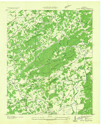
 1934 Unaka1934 Print · USGSCherokee County at the height of the New Deal era reveals a mountain landscape defined by the winding Hiwassee River and remote forest settlements. Genealogists can locate family landmarks such as Buckberry Sch, Bethel Cem, and the depression-era CCC Camp No F 11.
Showing maps 1-25 of 584
Top cities of Tennessee
- Nashville historical maps
- Memphis historical maps
- Knoxville historical maps
- Chattanooga historical maps
- Clarksville historical maps
- Murfreesboro historical maps
See more
Top counties of Tennessee
- Shelby County historical maps
- Davidson County historical maps
- Knox County historical maps
- Hamilton County historical maps
- Rutherford County historical maps
- Williamson County historical maps
See more
Frequently asked questions
- What are the different types of historical maps available for Tennessee?
- What is the oldest map of Tennessee?
- Where can I purchase historical maps of Tennessee for my home or office?
- Where can I download high-res historical maps of Tennessee?
- Are there historical topographic maps available for Tennessee?
- Is there historical aerial imagery available for Tennessee?
- Where are historical maps of Tennessee sourced from?