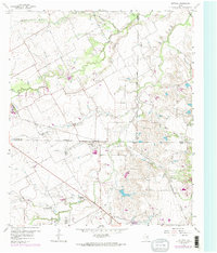
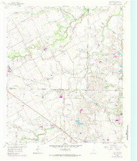
1959 Map of Britton
USGS Topo · Published 1984About this map
Britton serves as a central hub in this landscape where four Texas counties — Tarrant, Dallas, Ellis, and Johnson — converge. The terrain is defined by a dense network of waterways, including Mountain Creek, Walnut Creek, and Bowman Branch, which dictate the placement of early infrastructure. The Southern Pacific railroad cuts diagonally across the quadrangle, passing through the heart of Britton and reflecting the transit-driven development of the late 1950s. Local history is anchored by rural spiritual and memorial sites such as Friendship Ch, St Paul Ch, and the Pleasant Valley Cem. Scattered Gravel Pits indicate localized extraction industries, while family names are preserved through landmarks like Estes Cem and Cope Cem, offering clear coordinates for genealogical research in this multi-county borderland.
Find a feature on this map
25 named features on this map. Tap any name to fly to it.
Don’t see what you’re looking for? This feature index may not catch every label — zoom into the map to look around manually.
Map Details
Editions of this 1959 Britton Map
6 editions found

Other maps of this area

1891 · Dallas
USGS Topo · 1:125,000

1891 · Cleburne
USGS Topo · 1:125,000

1893 · Dallas
USGS Topo · 1:125,000

1894 · Cleburne
USGS Topo · 1:125,000

1894 · Fort Worth
USGS Topo · 1:125,000

1954 · Dallas
USGS Topo · 1:250,000

1958 · Dallas
USGS Topo · 1:250,000

1959 · Kennedale
USGS Topo · 1:24,000

1959 · Arlington
USGS Topo · 1:24,000

1959 · Cedar Hill
USGS Topo · 1:24,000