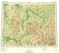
1955 Map of Candle
USGS Topo · Published 1961About this map
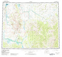
Candle serves as the northern hub of this mid-century Alaskan survey, situated near the Kiwalik Lagoon and a series of landing areas along the Kiwalik River. The landscape is defined by the extensive drainage systems of the Buckland River and its multiple forks, alongside the Koyuk River to the south. This era of exploration and resource extraction is marked by the presence of a Telephone Line and a lengthy Tractor Trail cutting through the interior, connecting remote outposts like Haycock and Dime Landing.
Find a feature on this map
78 named features on this map. Tap any name to fly to it.
Don’t see what you’re looking for? This feature index may not catch every label — zoom into the map to look around manually.
Map Details
Editions of this 1955 Candle Map
6 editions found

Other maps of this area

1945 · Nulato
USGS Topo · 1:250,000

1948 · Norton Bay
USGS Topo · 1:250,000

1950 · Kotzebue A-1
USGS Topo · 1:63,360

1950 · Bendeleben C-1
USGS Topo · 1:63,360

1950 · Bendeleben B-1
USGS Topo · 1:63,360

1950 · Bendeleben A-1
USGS Topo · 1:63,360

1950 · Norton Bay D-6
USGS Topo · 1:63,360

1950 · Bendeleben
USGS Topo · 1:250,000

1950 · Candle C-5
USGS Topo · 1:63,360

1950 · Norton Bay D-5
USGS Topo · 1:63,360