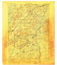
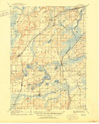
1906 Map of Eagle
USGS Topo · Published 1909About this map
Glacial topography and a dense network of early Wisconsin rail lines define this landscape at the turn of the century. Three major railroads—the Wisconsin Central Railroad, the Chicago and Northwestern Railroad, and the Chicago Milwaukee and St Paul Railroad—intersect the region, fostering settlements like Genesee Depot and North Prairie. The map illustrates a transition from the rolling hills of Ottawa and Genesee down to the water-rich basins of Mukwonago and East Troy. Numerous kettle lakes, including Beulah Lake, Phantom Lake, and Eagle Lake, are interspersed among the scattered villages. The southern reach is marked by Honey Creek and the Fox River, highlighting the significance of these waterways and rail spurs, like the Elkhorn Branch, in supporting the local agricultural economy and early industrial sites like Saylesville.
Find a feature on this map
53 named features on this map. Tap any name to fly to it.
Don’t see what you’re looking for? This feature index may not catch every label — zoom into the map to look around manually.
Map Details
Editions of this 1906 Eagle Map
6 editions found

Other maps of this area

1891 · Muskego
USGS Topo · 1:62,500

1892 · Waukesha
USGS Topo · 1:62,500

1892 · Watertown
USGS Topo · 1:62,500

1892 · Oconomowoc
USGS Topo · 1:62,500

1892 · Whitewater
USGS Topo · 1:62,500

1892 · Eagle
USGS Topo · 1:62,500

1893 · Delavan
USGS Topo · 1:62,500

1893 · Whitewater
USGS Topo · 1:62,500

1893 · Silver Lake
USGS Topo · 1:62,500

1893 · Geneva
USGS Topo · 1:62,500