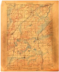
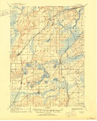
1906 Map of Eagle
USGS Topo · Published 1913About this map
Glacial geology and early rail lines define this landscape in the early twentieth century. The Fox River snakes through the eastern portion of the sheet, surrounded by extensive marshlands and lake systems including Mukwonago Lake and the prominent Lake Beulah. This region, split between Waukesha Co. and Walworth Co., was a primary transit corridor during the era, evidenced by the crossing of major lines like the Chicago Milwaukee And ST. Paul Railroad and the Wisconsin Central Railroad. Small settlements like Genesee Depot, North Prairie, and East Troy serve as central nodes for the surrounding agricultural community. The terrain is marked by distinct kettle lakes and wetlands, from Phantom Lake to Lulu Lake, reflecting the post-glacial topography typical of this part of Wisconsin. Researchers can trace the development of rural town centers like Eagle and Mukwonago before modern highway expansion altered their original footprints.
Find a feature on this map
55 named features on this map. Tap any name to fly to it.
Don’t see what you’re looking for? This feature index may not catch every label — zoom into the map to look around manually.
Map Details
Editions of this 1906 Eagle Map
6 editions found

Other maps of this area

1891 · Muskego
USGS Topo · 1:62,500

1892 · Waukesha
USGS Topo · 1:62,500

1892 · Watertown
USGS Topo · 1:62,500

1892 · Oconomowoc
USGS Topo · 1:62,500

1892 · Whitewater
USGS Topo · 1:62,500

1892 · Eagle
USGS Topo · 1:62,500

1893 · Delavan
USGS Topo · 1:62,500

1893 · Whitewater
USGS Topo · 1:62,500

1893 · Silver Lake
USGS Topo · 1:62,500

1893 · Geneva
USGS Topo · 1:62,500