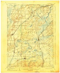
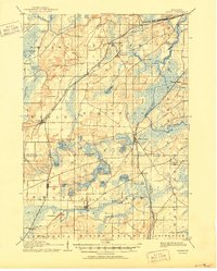
1906 Map of Eagle
USGS Topo · Published 1928About this map
The Fox River snakes through the eastern glacial landscape of this region, which was defined by a dense network of early Wisconsin rail lines and sprawling wetland lake systems at the turn of the century. The Chicago Milwaukee and St. Paul Railroad cuts diagonally across the center, connecting the village of Eagle with North Prairie and the Prairie du Chien Division. To the east, the Wisconsin Central Railroad passes through Mukwonago, following a corridor near Mukwonago Lake and the Millpond. This early survey highlights a distinct settlement pattern where towns like East Troy and Troy Center served as agricultural hubs, supported by the proximity of Honey Creek and Beulah Lake. The abundance of smaller water bodies, including Phantom Lake, Potter Lake, and Pickered Lake, suggests a landscape deeply shaped by post-glacial drainage, creating a complex environment for early transit and town planning.
Find a feature on this map
56 named features on this map. Tap any name to fly to it.
Don’t see what you’re looking for? This feature index may not catch every label — zoom into the map to look around manually.
Map Details
Editions of this 1906 Eagle Map
6 editions found

Other maps of this area

1891 · Muskego
USGS Topo · 1:62,500

1892 · Waukesha
USGS Topo · 1:62,500

1892 · Watertown
USGS Topo · 1:62,500

1892 · Oconomowoc
USGS Topo · 1:62,500

1892 · Whitewater
USGS Topo · 1:62,500

1892 · Eagle
USGS Topo · 1:62,500

1893 · Delavan
USGS Topo · 1:62,500

1893 · Whitewater
USGS Topo · 1:62,500

1893 · Silver Lake
USGS Topo · 1:62,500

1893 · Geneva
USGS Topo · 1:62,500