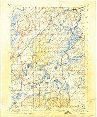
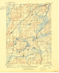
1906 Map of Eagle
USGS Topo · Published 1934About this map
Glacial topography and a dense network of early railways define this corner of Southeast Wisconsin as it appeared in the late nineteenth and early twentieth centuries. The landscape is characterized by numerous kettle lakes and wetland basins, including Lake Beulah and Phantom Lake, which shaped the early development of resort and farming communities. The Fox River flows through the eastern portion of the area, while the Wisconsin Central Railroad and the Chicago Milwaukee and St. Paul Railroad provided vital links for the movement of goods and people between the growing dairy towns.
Find a feature on this map
55 named features on this map. Tap any name to fly to it.
Don’t see what you’re looking for? This feature index may not catch every label — zoom into the map to look around manually.
Map Details
Editions of this 1906 Eagle Map
6 editions found

Other maps of this area

1891 · Muskego
USGS Topo · 1:62,500

1892 · Waukesha
USGS Topo · 1:62,500

1892 · Watertown
USGS Topo · 1:62,500

1892 · Oconomowoc
USGS Topo · 1:62,500

1892 · Whitewater
USGS Topo · 1:62,500

1892 · Eagle
USGS Topo · 1:62,500

1893 · Delavan
USGS Topo · 1:62,500

1893 · Whitewater
USGS Topo · 1:62,500

1893 · Silver Lake
USGS Topo · 1:62,500

1893 · Geneva
USGS Topo · 1:62,500