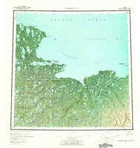
1955 Map of Harrison Bay
USGS Topo · Published 1963About this map
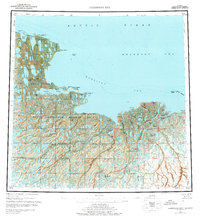
The Naval Petroleum Reserve No 4 dominates this mid-century portrait of the Arctic coastline, a region defined by intricate hydrological networks and coastal transition zones. Along the Beaufort Sea at Harrison Bay, the landscape is a mosaic of thaw lakes and complex river deltas. The massive Teshekpuk Lake stands as a focal point in the west, while the eastern portion is shaped by the expansive delta of the Colville River, where it splits into the Kupigruak Channel, Nechelik Channel, and Tamayayak Channel. Evidence of early 20th-century commerce is found at the Esook Trading Post (Aban'd) near Cape Halkett, marking a point where terrestrial and maritime economies once met. The map also traces the interior reaches of the Fish Creek and Kogru River systems, highlighting the remote character of the North Slope before significant infrastructure developments.
Find a feature on this map
38 named features on this map. Tap any name to fly to it.
Don’t see what you’re looking for? This feature index may not catch every label — zoom into the map to look around manually.
Map Details
Editions of this 1955 Harrison Bay Map
8 editions found
Other maps of this area

1951 · Harrison Bay
USGS Topo · 1:250,000

1951 · Beechey Point
USGS Topo · 1:250,000

1951 · Sagavanirktok D-5
USGS Topo · 1:250,000

1951 · Teshekpuk
USGS Topo · 1:250,000

1951 · Ikpikpuk River
USGS Topo · 1:250,000

1952 · Umiat
USGS Topo · 1:250,000

1955 · Harrison Bay
USGS Topo · 1:250,000

1955 · Beechey Point
USGS Topo · 1:250,000

1955 · Teshekpuk
USGS Topo · 1:250,000

1955 · Harrison Bay A-4
USGS Topo · 1:63,360