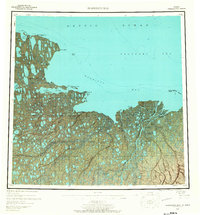
1955 Map of Harrison Bay
USGS Topo · Published 1967About this map
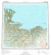
The northern Alaskan coast at Harrison Bay reveals a landscape defined by an intricate network of Arctic waterways and the vast extent of Naval Petroleum Reserve No 4. The map documents a period of transition along the Arctic Ocean shoreline, where the abandoned Esook Trading Post at Cape Halkett sits as a remnant of earlier commercial ventures. The delta region where the Colville River meets the Beaufort Sea is characterized by shifting channels like the Kupigruak Channel and the Oliktok Channel, surrounding low-lying features such as Anachlik Island and Nuekshat Island. Inland, the tundra is pockmarked with thousands of lakes, dominated by the massive Teshekpuk Lake. Local landmarks like Kachemach Mound and Pikonik Mound rise above the drainage basins of the Itkillik River and Fish Creek, providing rare topographic variation in this water-saturated coastal plain.
Find a feature on this map
45 named features on this map. Tap any name to fly to it.
Don’t see what you’re looking for? This feature index may not catch every label — zoom into the map to look around manually.
Map Details
Editions of this 1955 Harrison Bay Map
8 editions found
Other maps of this area

1951 · Harrison Bay
USGS Topo · 1:250,000

1951 · Beechey Point
USGS Topo · 1:250,000

1951 · Sagavanirktok D-5
USGS Topo · 1:250,000

1951 · Teshekpuk
USGS Topo · 1:250,000

1951 · Ikpikpuk River
USGS Topo · 1:250,000

1952 · Umiat
USGS Topo · 1:250,000

1955 · Harrison Bay
USGS Topo · 1:250,000

1955 · Beechey Point
USGS Topo · 1:250,000

1955 · Teshekpuk
USGS Topo · 1:250,000

1955 · Harrison Bay A-4
USGS Topo · 1:63,360