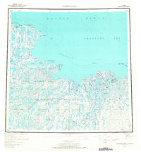
1955 Map of Harrison Bay
USGS Topo · Published 1967About this map
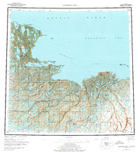
The Naval Petroleum Reserve No 4 dominates this stretch of the Arctic coast, where the vast, water-rich landscape is defined by an intricate network of deltas and thousands of tundra lakes. The map details the complex confluence of the Colville River and the Kuparik River as they feed into Harrison Bay, revealing a labyrinth of tidal passages including the Kppigruak Channel and Elaktovach Channel. This mid-century view documents the region's geography just as modern exploration began to intensify, capturing the location of the Esook Trading Post (Aband) near Cape Halkett and a solitary Cabin to the east.
Find a feature on this map
41 named features on this map. Tap any name to fly to it.
Don’t see what you’re looking for? This feature index may not catch every label — zoom into the map to look around manually.
Map Details
Editions of this 1955 Harrison Bay Map
8 editions found
Other maps of this area

1951 · Harrison Bay
USGS Topo · 1:250,000

1951 · Beechey Point
USGS Topo · 1:250,000

1951 · Sagavanirktok D-5
USGS Topo · 1:250,000

1951 · Teshekpuk
USGS Topo · 1:250,000

1951 · Ikpikpuk River
USGS Topo · 1:250,000

1952 · Umiat
USGS Topo · 1:250,000

1955 · Harrison Bay
USGS Topo · 1:250,000

1955 · Beechey Point
USGS Topo · 1:250,000

1955 · Teshekpuk
USGS Topo · 1:250,000

1955 · Harrison Bay A-4
USGS Topo · 1:63,360