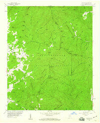
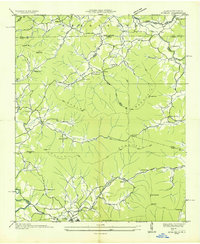
1957 Map of Jacks Gap
USGS Topo · Published 1960About this map
Chattahoochee National Forest dominates this mountain landscape, which includes portions of Union, Towns, and White counties. The topography is defined by the Blue Ridge Divide and the Valley Divide, where the legendary Appalachian Trail follows the high ridgelines through Wolf Stake Gap and over Sheep Rock Top. This 1957 survey captures the rural infrastructure of the North Georgia highlands, highlighting the settlement at Town and nearby educational and spiritual centers like Town Creek Sch, Old Liberty Ch, and Pine Top Ch. The drainage patterns are intricate, with the Nottely River and creeks such as Arkaqua Creek and Stink Smell Creek carving deep valleys between peaks like Cedar Mtn and Frozentop. A significant historical transport corridor is also visible in the form of the Unicoi Turnpike, which crosses the southern portion of the map.
Find a feature on this map
127 named features on this map. Tap any name to fly to it.
Don’t see what you’re looking for? This feature index may not catch every label — zoom into the map to look around manually.
Map Details
Editions of this 1957 Jacks Gap Map
4 editions found
Other maps of this area

1886 · Dahlonega
USGS Topo · 1:125,000

1892 · Dahlonega
USGS Topo · 1:125,000

1896 · Dahlonega
USGS Topo · 1:125,000

1903 · Dahlonega
USGS Topo · 1:125,000

1935 · Coosa Bald
USGS Topo · 1:24,000

1935 · Osborn
USGS Topo · 1:24,000

1935 · Cowrock
USGS Topo · 1:24,000

1935 · Tray Mountain
USGS Topo · 1:24,000
1935 · Gumlog
USGS Topo · 1:24,000

1935 · Jacks Gap
USGS Topo · 1:24,000