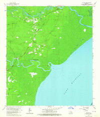
1963 Map of Killian
USGS Topo · Published 1964About this map
The confluence of the Tickfaw River and Amite River at the northern edge of Lake Maurepas defines this coastal Louisiana landscape. Settlement is concentrated along the higher ground and winding waterways, notably at Killian and Clio. This mid-century survey illustrates the rural nature of Livingston Parish before significant modern development, where family names and local congregations serve as the primary landmarks. Small rural churches like Bethlehem Ch and Huff Chapel anchor the community, while the drainage of the surrounding wetlands is managed through a network of artificial channels including the Cutoff Canal and Lake Shore Canal.
Find a feature on this map
22 named features on this map. Tap any name to fly to it.
Don’t see what you’re looking for? This feature index may not catch every label — zoom into the map to look around manually.
Map Details
Editions of this 1963 Killian Map
4 editions found
Other maps of this area

1892 · Mount Airy
USGS Topo · 1:62,500

1892 · Bonnet Carre
USGS Topo · 1:62,500

1934 · Springfield
USGS Topo · 1:62,500

1935 · Ponchatoula
USGS Topo · 1:62,500

1936 · Ruddock
USGS Topo · 1:31,680

1936 · Bonnet Carre
USGS Topo · 1:62,500

1939 · Ponchatoula
USGS Topo · 1:62,500

1939 · Springfield
USGS Topo · 1:62,500

1946 · North of Garyville
USGS Topo · 1:31,680

1946 · Petite Amite River
USGS Topo · 1:31,680