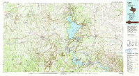
1992 Map of Llano
USGS Topo · Published 1992About this map
The Llano River and the Colorado River converge in this central Texas landscape, defined by the massive granite uplift of Enchanted Rock and the extensive Highland Lakes system. This early 1990s record details the complex hydrology of the region, anchored by the sprawling Lake Buchanan and a series of downstream reservoirs including Inks Lake and Lake Lyndon B Johnson. Small rural communities like Castell, Field Creek, and Babyhead reflect the deep ranching and agricultural roots of Llano and Burnet counties, while the growing footprint of Sunrise Beach Village illustrates the era's expanding residential lakefront development.
Find a feature on this map
144 named features on this map. Tap any name to fly to it.
Don’t see what you’re looking for? This feature index may not catch every label — zoom into the map to look around manually.
Map Details
Editions of this 1992 Llano Map
2 editions found
Other maps of this area

1885 · San Saba
USGS Topo · 1:125,000

1887 · Llano
USGS Topo · 1:125,000

1887 · Lampasas
USGS Topo · 1:125,000

1887 · Blanco
USGS Topo · 1:125,000

1887 · Mason
USGS Topo · 1:125,000

1887 · Burnet
USGS Topo · 1:125,000

1893 · Georgetown
USGS Topo · 1:125,000

1893 · Burnet
USGS Topo · 1:125,000

1894 · Brady
USGS Topo · 1:125,000

1894 · Mason
USGS Topo · 1:125,000