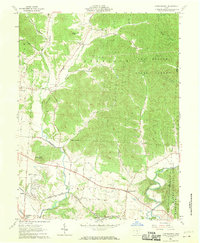
1961 Map of Londonderry
USGS Topo · Published 1970About this map
Londonderry and its surrounding townships in Ross County are captured here during the early 1960s, a period of transition as much of the eastern landscape was conserved within the Tar Hollow State Forest and Wayne National Forest. The local economy and geography are defined by the Baltimore and Ohio Railroad, which cuts through the southern valley floor near Vigo and Schooley. This survey provides a look at rural Ohio's social fabric through its numerous small congregations and burial grounds, such as the Church of the Brethren, Kingdom of Heaven Ch, and the Claypool Cem. The terrain is famously punctuated by landmarks like Rattlesnake Knob and Point Lookout, while many smaller settlements like Lickskillet and Mooresville illustrate the dispersed residential pattern of the era. Evidence of local industry is sparse but present, including a Gravel Pit near Rupels.
Find a feature on this map
47 named features on this map. Tap any name to fly to it.
Don’t see what you’re looking for? This feature index may not catch every label — zoom into the map to look around manually.
Map Details
Editions of this 1961 Londonderry Map
3 editions found
Other maps of this area

1906 · Waverly
USGS Topo · 1:62,500

1906 · Chillicothe
USGS Topo · 1:62,500

1908 · Chillicothe
USGS Topo · 1:62,500

1908 · Waverly
USGS Topo · 1:62,500

1910 · Laurelville
USGS Topo · 1:62,500

1912 · Laurelville
USGS Topo · 1:62,500

1913 · Jackson
USGS Topo · 1:62,500

1944 · Jackson
USGS Topo · 1:62,500

1944 · Laurelville
USGS Topo · 1:62,500

1947 · Columbus
USGS Topo · 1:250,000