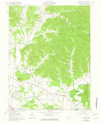
1961 Map of Londonderry
USGS Topo · Published 1982About this map
Londonderry serves as the primary hub for this portion of the Ross and Vinton County line, centered along the Baltimore and Ohio rail corridor. The map reveals a landscape defined by deep valleys and prominent elevations like Rattlesnake Knob and Point Lookout, where the wooded ridges of the Tar Hollow State Forest and Wayne National Forest dominate the northeastern and southeastern quadrants. Small agricultural settlements and crossroads like Tucson, Mooresville, and the curiously named Lickskillet are scattered throughout the lowlands.
Find a feature on this map
54 named features on this map. Tap any name to fly to it.
Don’t see what you’re looking for? This feature index may not catch every label — zoom into the map to look around manually.
Map Details
Editions of this 1961 Londonderry Map
3 editions found
Other maps of this area

1906 · Waverly
USGS Topo · 1:62,500

1906 · Chillicothe
USGS Topo · 1:62,500

1908 · Chillicothe
USGS Topo · 1:62,500

1908 · Waverly
USGS Topo · 1:62,500

1910 · Laurelville
USGS Topo · 1:62,500

1912 · Laurelville
USGS Topo · 1:62,500

1913 · Jackson
USGS Topo · 1:62,500

1944 · Jackson
USGS Topo · 1:62,500

1944 · Laurelville
USGS Topo · 1:62,500

1947 · Columbus
USGS Topo · 1:250,000