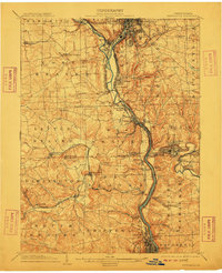
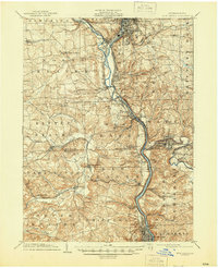
1904 Map of Newcastle
USGS Topo · Published 1910About this map
The confluence of the Mahoning River and the Shenango River forms a dense industrial corridor at the heart of this early twentieth-century survey. Massive rail infrastructure, including the Pittsburg Youngstown and Ashtabula Div and the Baltimore and Ohio RR, traces the river valleys to serve the region's burgeoning manufacturing and extractive industries. The landscape is dotted with company towns and railway junctions like Mahoningtown, Newcastle Junction, and Lawrence Junction, reflecting the era's heavy reliance on steam-powered transport.
Find a feature on this map
87 named features on this map. Tap any name to fly to it.
Don’t see what you’re looking for? This feature index may not catch every label — zoom into the map to look around manually.
Map Details
Editions of this 1904 Newcastle Map
6 editions found
Other maps of this area

1901 · Beaver
USGS Topo · 1:62,500

1902 · New Castle
USGS Topo · 1:62,500

1904 · Newcastle
USGS Topo · 1:62,500

1904 · Wellsville
USGS Topo · 1:62,500

1904 · Beaver
USGS Topo · 1:62,500

1905 · Neshannock
USGS Topo · 1:62,500

1906 · Youngstown
USGS Topo · 1:62,500

1906 · Sewickley
USGS Topo · 1:62,500

1907 · Neshannock
USGS Topo · 1:62,500

1907 · Columbiana
USGS Topo · 1:62,500