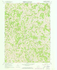
1961 Map of Oak Forest
USGS Topo · Published 1973About this map
Greene County’s dissected plateau landscape is defined here by a dense network of winding valleys and family-named ridges. Small rural hubs like Oak Forest and Spraggs serve as anchor points for a community of farms connected by gravel roads and creek-side tracks. The mapping reveals a social landscape organized around local institutions, including the Township Sch and Shannon Run Sch, alongside numerous hilltop burial grounds such as Gordon Cem and White Cem.
Find a feature on this map
39 named features on this map. Tap any name to fly to it.
Don’t see what you’re looking for? This feature index may not catch every label — zoom into the map to look around manually.
Map Details
Editions of this 1961 Oak Forest Map
4 editions found
Other maps of this area

1901 · Waynesburg
USGS Topo · 1:62,500

1904 · Blacksville
USGS Topo · 1:62,500

1904 · Waynesburg
USGS Topo · 1:62,500

1905 · Mannington
USGS Topo · 1:62,500

1905 · Rogersville
USGS Topo · 1:62,500

1923 · Blacksville
USGS Topo · 1:62,500

1923 · Mannington
USGS Topo · 1:62,500

1925 · Blacksville
USGS Topo · 1:62,500

1926 · Mannington
USGS Topo · 1:62,500

1949 · Clarksburg
USGS Topo · 1:250,000