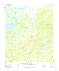
1952 Map of Ruby D-2
USGS Topo · Published 1975About this map
The Little Mud River winds through this interior Alaskan wilderness, defined by an intricate network of wetlands and drainage patterns captured during a 1952 aerial survey. The terrain transitions from the low-lying, saturated basins of the river valley to the more defined relief surrounding Bering Creek in the northeastern reaches. This map provides a technical view of a landscape essentially untouched by permanent road infrastructure or industrial development at the time of the survey. The mapping process relied heavily on photogrammetric methods to interpret the vast stretches of swamps and muskeg, offering a distinct record of the natural hydrology and topographical contours before any modern modifications or shifts in the northern environment.
Find a feature on this map
2 named features on this map. Tap any name to fly to it.
Don’t see what you’re looking for? This feature index may not catch every label — zoom into the map to look around manually.
Map Details
Editions of this 1952 Ruby D-2 Map
4 editions found
Other maps of this area

1951 · Ruby
USGS Topo · 1:250,000

1951 · Melozitna
USGS Topo · 1:250,000

1952 · Ruby C-3
USGS Topo · 1:63,360

1952 · Ruby C-1
USGS Topo · 1:63,360

1952 · Melozitna A-2
USGS Topo · 1:63,360

1952 · Ruby D-1
USGS Topo · 1:63,360

1952 · Ruby C-2
USGS Topo · 1:63,360

1952 · Ruby D-3
USGS Topo · 1:63,360

1952 · Ruby D-2
USGS Topo · 1:63,360

1952 · Ruby
USGS Topo · 1:250,000