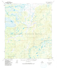
1952 Map of Ruby D-2
USGS Topo · Published 1992About this map
Nowitna National Wildlife Refuge dominates this subarctic landscape in the early 1950s, a region defined by an intricate network of wetlands and meandering waterways. The topography, mapped via aerial photogrammetry in 1952, reveals a dense mosaic of lakes and ponds that characteristically saturate the lowlands surrounding Bering Creek. These seasonal water bodies and marshes transition into higher ground toward the south, where the elevation is marked by survey points like VABM Little 1149. The presence of the Little Mud River in the southeast indicates the complex drainage patterns typical of the Yukon River watershed. This survey captures the wilderness in a transitional state, showing the vast unsurveyed and unmarked land lines predetermined by the Bureau of Land Management before extensive ground surveying had reached this interior corridor.
Find a feature on this map
4 named features on this map. Tap any name to fly to it.
Don’t see what you’re looking for? This feature index may not catch every label — zoom into the map to look around manually.
Map Details
Editions of this 1952 Ruby D-2 Map
4 editions found
Other maps of this area

1951 · Ruby
USGS Topo · 1:250,000

1951 · Melozitna
USGS Topo · 1:250,000

1952 · Ruby C-3
USGS Topo · 1:63,360

1952 · Ruby C-1
USGS Topo · 1:63,360

1952 · Melozitna A-2
USGS Topo · 1:63,360

1952 · Ruby D-1
USGS Topo · 1:63,360

1952 · Ruby C-2
USGS Topo · 1:63,360

1952 · Ruby D-3
USGS Topo · 1:63,360

1952 · Ruby D-2
USGS Topo · 1:63,360

1952 · Ruby
USGS Topo · 1:250,000