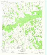
1960 Map of Streetman
USGS Topo · Published 1975About this map
Streetman sits at the intersection of vital transport lines in the late 1950s, marking the boundary where the Fort Worth and Denver and Chicago Rock Island and Pacific railroads meet. The landscape north of the town is defined by the broad floodplain of Richland Creek, which winds through the central portion of the survey. This drainage system, including Grape Creek and Crab Creek, creates a distinct pattern of wooded bottoms and open upland fields.
Find a feature on this map
17 named features on this map. Tap any name to fly to it.
Don’t see what you’re looking for? This feature index may not catch every label — zoom into the map to look around manually.
Map Details
Editions of this 1960 Streetman Map
4 editions found
Other maps of this area

1954 · Dallas
USGS Topo · 1:250,000

1954 · Waco
USGS Topo · 1:250,000

1955 · Waco
USGS Topo · 1:250,000

1958 · Dallas
USGS Topo · 1:250,000

1959 · Powell
USGS Topo · 1:24,000

1960 · Winkler
USGS Topo · 1:24,000

1960 · Streetman
USGS Topo · 1:24,000

1960 · Goodlow Park
USGS Topo · 1:24,000

1963 · Richland
USGS Topo · 1:24,000

1963 · Wortham
USGS Topo · 1:24,000