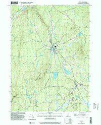
1998 Map of Troy
USGS Topo · Published 2002About this map
Troy and its surrounding Cheshire County townships are characterized by a dense network of water bodies and conservation lands at the close of the 20th century. Industrial remnants like the Quarry and various Sandpits are scattered near the town center, while the landscape is defined by substantial state-managed areas such as Rhododendron State Park and the Gay State Forest. The topography is marked by significant elevations like Gap Mtn and Little Monadnock Mountain, which overlook a complex hydrology including Rockwood Pond and the West Hill Reservoir.
Find a feature on this map
70 named features on this map. Tap any name to fly to it.
Don’t see what you’re looking for? This feature index may not catch every label — zoom into the map to look around manually.
Map Details
Editions of this 1998 Troy Map
This is the sole edition of this map. No revisions or reprints were ever made.
Other maps of this area

1887 · Warwick
USGS Topo · 1:62,500

1887 · Winchendon
USGS Topo · 1:62,500

1889 · Warwick
USGS Topo · 1:62,500

1890 · Winchendon
USGS Topo · 1:62,500

1894 · Winchendon
USGS Topo · 1:62,500

1894 · Warwick
USGS Topo · 1:62,500

1898 · Monadnock
USGS Topo · 1:62,500

1898 · Keene
USGS Topo · 1:62,500

1932 · Warwick
USGS Topo · 1:48,000

1932 · Winchendon
USGS Topo · 1:48,000