1900-1909 Maps of Georgia
Explore 50 historic maps of Georgia from 1900-1909. These maps offer a rare glimpse into what life looked like during the 1900s — showing old roads, neighborhoods, homes, and landmarks that have changed or disappeared over time.
Whether you're researching your family's past, planning a metal detecting trip, or studying how Georgia's landscape evolved across the 1900s, these high-resolution maps are a powerful tool for exploring the history of this region.
- Focus on a specific era: All maps on this page are from the 1900s, giving you a focused view of this time period.
- See what’s changed: Compare century-old streets, trails, and buildings to today's modern landscape using overlays and satellite layers.
- Research with precision: Use these maps for genealogy, historical research, land use analysis, or educational projects.
- View, download, or print: Maps are fully viewable online in high resolution, and can be downloaded or printed for your own records.
Start exploring Georgia's history through authentic maps from the 1900s. This is your window into the past.
Georgia maps
- 1900 Map of Fort Payne
 1900 Fort Payne1900 Print · USGSNortheast Alabama is defined by its deep ridges and river valleys in the late nineteenth century. Researchers can trace the era's ferry network across the Coosa River and find old family-run landmarks like Wagners Store and Santy Mills.6 unique versions available
 - 1901 Map of Marietta
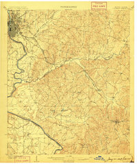
 1901 Marietta1901 Print · USGSNorthwest Georgia at the turn of the century is a landscape of growing rail towns and vital river crossings. Researchers can trace early rural life through features like Old Villarica, Pumpkintown Ferry, and the Mount Zion Church.4 unique versions available
 - 1902 Map of Wedowee
 1902 Wedowee1902 Print · USGSThe Alabama and Georgia state line bisects this turn-of-the-century landscape of river crossings and hill-country settlements. Genealogists can trace early homesteads and commerce at Philpots Ferry, the Copper Mine, or the town of Wedowee.3 unique versions available
 - 1903 Map of Dahlonega
 1903 Dahlonega1903 Print · USGSNorth Georgia and the Blue Ridge were defined by mountain settlements and early industry at the turn of the century. Genealogists and historians can trace family locations across the Nacoochee Valley, locate the Asbestos Mines, or find old sites like Loudsville and Porter Springs.5 unique versions available
 - 1904 Map of Rome
 1904 Rome1904 Print · USGSNorthwest Georgia and the Alabama borderlands are captured here during a period of heavy river traffic and expanding rail lines. Genealogists can trace family footprints across dozens of river crossings like Freeman Ferry and early settlements such as Chubbtown or Raccoon Mills.4 unique versions available
 - 1906 Map of Crawfordville
 1906 Crawfordville1906 Print · USGSUpper Georgia and the South Carolina border come alive in this early century survey, showing a landscape defined by river ferries and mining sites. Genealogists can trace family roots through old post offices like Triplett P.O. or find historic crossings like Fishdam Ferry and the Columbia Mines.3 unique versions available
 - 1906 Map of Stilesboro, 1971 Print
 1906 Stilesboro1971 Print · USGSBartow County at the turn of the century was a bustling nexus of rail and river commerce before the modern highway era. Genealogists and historians can trace the foundations of Cartersville and find rural landmarks like Euharlee Ch, Malbone, and Petrobutte PO.
 - 1907 Map of Cowee
 1907 Cowee1907 Print · USGSWestern North Carolina at the turn of the century shows a landscape of rail-connected river towns and high mountain gaps. Genealogists can trace early homesteads and industry through landmarks like West Mill, Roanes Mill, and the many settlements along the Southern Railway.5 unique versions available
 - 1907 Map of Talbotton
 1907 Talbotton1907 Print · USGSWest-central Georgia at the turn of the century is a landscape of ridges and rail-lines, dominated by the thermal waters of Warm Springs. Local historians can trace the foundations of Talbotton and rural life at Turntime Crossroads, Cataula Camp Ground, and Greens Mill.3 unique versions available
 - 1907 Map of Acworth, 1954 Print
 1907 Acworth1954 Print · USGSNorthern Georgia's river-and-rail corridor is captured here at the start of the twentieth century. Genealogists can trace family roots near Acworth and Kennesaw or locate old crossings like Island Mills Ferry and Steels Bridge.
 - 1907 Map of Opelika, 1963 Print
 1907 Opelika1963 Print · USGSEastern Alabama and western Georgia come alive in this early 1900s survey of the rail-and-river economy. Genealogists can trace family names at Mitchell Crossroads, find rural landmarks like the Poor Farm, and locate historic river crossings like Dixon Ferry.
 - 1908 Map of Columbus
 1908 Columbus1908 Print · USGSThe Chattahoochee riverfront at the dawn of the century shows the thriving river-and-rail economy of the Georgia-Alabama border. Genealogists and historians can trace early landings like BRADLEY LDG, rural congregations at Goodhope Church, and the operations at Cooks Mill.8 unique versions available
 - 1908 Map of Stilesboro
 1908 Stilesboro1908 Print · USGSBartow County's industrial and agricultural landscape at the turn of the century is defined by its busy rail junctions and the winding Etowah River. Genealogists and historians can trace the early road networks and rail stops from Cartersville to Stilesboro, finding named points like Rogers Ferrobutte PO and Harden Bridge.
 - 1909 Map of Opelika
 1909 Opelika1909 Print · USGSEastern Alabama and western Georgia are seen here in the first decade of the twentieth century as the river-and-rail economy reached its peak. Genealogists and historians can trace old river crossings like Blanton Ferry, rural post offices such as Antioch Church Huckabee P O, and the path of the Chattahoochee Valley railroad.4 unique versions available
 - 1909 Map of Acworth
 1909 Acworth1909 Print · USGSNorth Georgia at the turn of the century shows a landscape of river ferries and emerging rail towns before the creation of modern reservoirs. Genealogists can trace family footprints near Acworth and Woodstock, or locate historic crossings like Island Mills Ferry and Steels Bridge.
End of results
Showing maps 1-15
Top cities of Georgia
- Atlanta historical maps
- Augusta historical maps
- Columbus historical maps
- Macon historical maps
- Savannah historical maps
- Athens historical maps
See more
Top counties of Georgia
- Fulton County historical maps
- Gwinnett County historical maps
- Cobb County historical maps
- DeKalb County historical maps
- Chatham County historical maps
- Clayton County historical maps
See more
Frequently asked questions
- What are the different types of historical maps available for Georgia?
- What is the oldest map of Georgia?
- Where can I purchase historical maps of Georgia for my home or office?
- Where can I download high-res historical maps of Georgia?
- Are there historical topographic maps available for Georgia?
- Is there historical aerial imagery available for Georgia?
- Where are historical maps of Georgia sourced from?