1930s Maps of Georgia
Explore 58 historic maps of Georgia from the 1930s. These maps offer a rare glimpse into what life looked like during the 1930s — showing old roads, neighborhoods, homes, and landmarks that have changed or disappeared over time.
Whether you're researching your family's past, planning a metal detecting trip, or studying how Georgia's landscape evolved across the 1930s, these high-resolution maps are a powerful tool for exploring the history of this region.
- Focus on a specific era: All maps on this page are from the 1930s, giving you a focused view of this time period.
- See what’s changed: Compare century-old streets, trails, and buildings to today's modern landscape using overlays and satellite layers.
- Research with precision: Use these maps for genealogy, historical research, land use analysis, or educational projects.
- View, download, or print: Maps are fully viewable online in high resolution, and can be downloaded or printed for your own records.
Start exploring Georgia's history through authentic maps from the 1930s. This is your window into the past.
Georgia maps
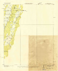
(58)- 1930 Map of Cumberland Island
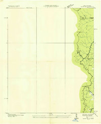
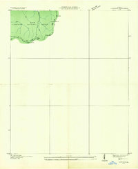
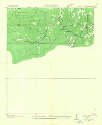
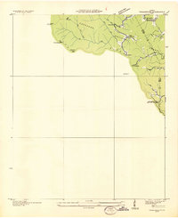
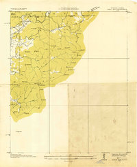
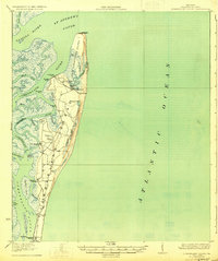 1930 Cumberland Island1930 Print · USGSCoastal Camden County during the interwar years is defined by the private estates and tidal marshes of this barrier island. Trace the early estate culture through Greyfield and the numerous landings like Stafford Wharf and the Lighthouse (Abandoned).3 unique versions available
 - 1934 Map of Warm Springs, 1958 Print
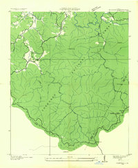
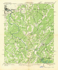
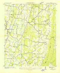
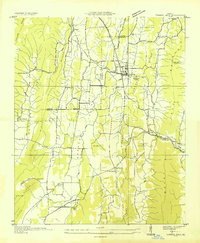
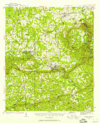 1934 Warm Springs1958 Print · USGSWest-central Georgia at the height of the New Deal era reveals a landscape of therapeutic springs, mountain gaps, and busy rail junctions. Genealogists and historians can locate family landmarks like Williams Chapel, the Warm Springs Foundation, and Chalybeate Springs along the rugged Pine Mountain ridge.7 unique versions available
 - 1935 Map of Epworth
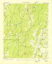
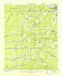 1935 Epworth1935 Print · USGSNorth Georgia and the Tennessee borderlands are captured here in the mid-1930s, showing a landscape defined by copper mining and mountain farming. Researchers can locate vanished landmarks like Higdons Store, trace the Louisville and Nashville rail line, or find family roots at Madola Sch and Hipp Chapel.
 - 1935 Map of Catlett
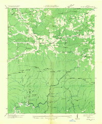
 1935 Catlett1935 Print · USGSThe Walker and Whitfield county line comes alive in the mid-1930s, showing a rural Georgia landscape of high ridges and valley farms. Researchers can trace family ties at Gladden Cem or locate the old Pine Grove Sch and Henderson Sch near the crossing of Catlett Creek.
 - 1935 Map of East Ridge
 1935 East Ridge1935 Print · USGSThe Georgia-Tennessee borderlands appear here in the mid-1930s, showing the intersection of military history and rural development. You can trace the early layout of East Ridge and locate family landmarks like Lomemick Cem, Burning Bush Sch, and Boynton.
 - 1935 Map of Coosa Bald
 1935 Coosa Bald1935 Print · USGSUnion County, Georgia, is captured during the mid-thirties as the river valleys were being surveyed for infrastructure and conservation. Genealogists and historians can trace family locations near Cowden Cem, Choestoe, and rural landmarks like Trackrock School.
 - 1935 Map of Ivylog
 1935 Ivylog1935 Print · USGSUnion County, Georgia, and the North Carolina borderlands are captured here in the mid-1930s before major dam projects reshaped the river valleys. Genealogists and local historians can trace family roots through numerous country landmarks like Ivylog Cem, Mt Zion Sch, and Davenport Mill.
 - 1935 Map of Mulky Gap
 1935 Mulky Gap1935 Print · USGSUnion and Fannin Counties were characterized by small mills and mountain gaps in the mid-1930s. Genealogists can trace family roots at Jones Cem or Harkins Cem, while historians can locate CCC Camp No F-12 and Clements Mills.
 - 1935 Map of Osborn
 1935 Osborn1935 Print · USGSTowns County, Georgia, is documented here in the mid-1930s before the full expansion of the Tennessee Valley Authority’s projects. Local historians can trace family locations and rural community hubs like Osborn, Macedonia Ch, and Upper Bell Sch.
 - 1935 Map of Tiger Creek
 1935 Tiger Creek1935 Print · USGSThe Tennessee and Georgia borderlands meet along the ridges of Whitfield and Catoosa counties in the mid-1930s. Genealogists and historians can trace family land along Tiger Creek and locate the Southern railroad crossing at White Cut.
 - 1935 Map of Hemp Top
 1935 Hemp Top1935 Print · USGSHigh in the mountains along the Georgia-Tennessee border in the mid-1930s, this survey documents the ridge-line terrain of the Blue Ridge. Researchers can locate remote landmarks like the Fire Tower on Hemp Top, Ashe Mill, and Dally Gap.
 - 1935 Map of Cowrock
 1935 Cowrock1935 Print · USGSThe northern Georgia high country is captured here during the mid-1930s as federal agencies mapped the watershed for the Tennessee Valley Authority. Hikers and historians can trace the early route of the Appalachian Trail through Tesnatee Gap and past the summit of Cowrock Mtn.
 - 1935 Map of Noontootla
 1935 Noontootla1935 Print · USGSNorth Georgia's mountain ridges and valley settlements are captured here in the mid-1930s as the Tennessee Valley Authority and USGS surveyed the region. Researchers can trace the early APPALACHIAN TRAIL past the FIRE TOWER on Hawk Mtn and locate sites like Stock Hill Ch or the Rock Creek Cem.
 - 1935 Map of Mineral Bluff
 1935 Mineral Bluff1935 Print · USGSThe tri-state border region of Georgia, Tennessee, and North Carolina comes alive in the mid-1930s as industry and infrastructure reshape the mountain landscape. Genealogists can locate family landmarks like Paintertown Sch, Shady Grove Ch, and the homes near Mineral Bluff.
 - 1935 Map of Durham
 1935 Durham1935 Print · USGSNorthwest Georgia's industrial and rural landscape is documented here during the mid-1930s as mining and rail commerce defined the region. Researchers can trace the heritage of Durham and Cassandra through sites like Coal Mines, Prospect Sch, and Fuggett Ch.
 - 1935 Map of Cashiers
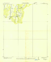
 1935 Cashiers1935 Print · USGSJackson County and the North Carolina-South Carolina border appear here in the mid-1930s as modern surveying techniques were first being applied. Researchers can trace early state infrastructure such as St Hy No 106 as it passes through the Nantahala National Forest.
 - 1935 Map of Villanow
 1935 Villanow1935 Print · USGSThe borderlands of Whitfield and Walker Counties are captured here in the mid-1930s as the TVA began its regional work. Genealogists can locate rural landmarks like Friendship Ch, Fairview Sch, and the small settlement of Reo.
 - 1935 Map of Ringgold
 1935 Ringgold1935 Print · USGSThe Georgia-Tennessee borderlands in the mid-1930s are anchored by the town of Ringgold and the central Military Reservation. Genealogists and historians can trace community roots at Salem Ch, Ebenezer Ch, and the rural Union Academy.
 - 1935 Map of Cashes Valley
 1935 Cashes Valley1935 Print · USGSCashes Valley and the North Georgia mountains come alive in this mid-1930s survey of the Fannin and Gilmer borderlands. Genealogists can trace family footprints near Cashes Valley Ch, Madola Sch, and the isolated homesteads along Fightingtown Creek.
 - 1935 Map of Nickajack Gap
 1935 Nickajack Gap1935 Print · USGSCatoosa and Walker Counties are captured in the mid-1930s as a landscape of ridges and rural settlements. Researchers can locate family landmarks like Mc Intyre Cem, Peavine Ch, and the school at Mt Pisgah Sch.
 - 1935 Map of Lake Toccoa
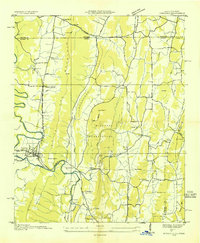
 1935 Lake Toccoa1935 Print · USGSNorth Georgia’s mountain and river life is preserved here during the mid-1930s transition into the hydroelectric era. Researchers can trace family roots through the numerous rural schools and churches, such as Stanley Creek Sch, Union Ch, and landmarks like Stanley Mill.
 - 1935 Map of Dillard
 1935 Dillard1935 Print · USGSThe Georgia and North Carolina borderlands are captured here in the mid-1930s as the rail and highway networks expanded through the mountains. Researchers can locate the Rabun Gap Nacoochee Sch, trace the Tallulah Falls RR, and find local landmarks like Wolf Fork Ch.
 - 1935 Map of Tickanetley
 1935 Tickanetley1935 Print · USGSHigh in the Blue Ridge mountains during the mid-1930s, this survey captures the rural crossroads of Gilmer and Fannin counties. Genealogists can trace early landmarks like Big Creek Ch, Stanley Mill, and the combined Mathis Chapel Sch.
 - 1935 Map of Rabun Bald
 1935 Rabun Bald1935 Print · USGSThe Georgia and North Carolina high country is captured here during the mid-thirties, dominated by the ridge lines of the Blue Ridge. Researchers can trace old mountain trails to landmarks like the Fire Tower at Rabun Bald or locate family sites near Dillard and Stillhouse Creek.
 - 1935 Map of Tunnel Hill
 1935 Tunnel Hill1935 Print · USGSNorthwest Georgia's ridge-and-valley landscape is captured here in the mid-1930s as the rail and highway networks evolved. Genealogists and historians can trace family-named sites like Foster Cem, old schoolhouses such as West Side Sch, and the landmark Chetoogeta Mountain Tunnel.
Showing maps 1-25 of 58
Top cities of Georgia
- Atlanta historical maps
- Augusta historical maps
- Columbus historical maps
- Macon historical maps
- Savannah historical maps
- Athens historical maps
See more
Top counties of Georgia
- Fulton County historical maps
- Gwinnett County historical maps
- Cobb County historical maps
- DeKalb County historical maps
- Chatham County historical maps
- Clayton County historical maps
See more
Frequently asked questions
- What are the different types of historical maps available for Georgia?
- What is the oldest map of Georgia?
- Where can I purchase historical maps of Georgia for my home or office?
- Where can I download high-res historical maps of Georgia?
- Are there historical topographic maps available for Georgia?
- Is there historical aerial imagery available for Georgia?
- Where are historical maps of Georgia sourced from?