1910s Maps of Georgia
Explore 34 historic maps of Georgia from the 1910s. These maps offer a rare glimpse into what life looked like during the 1910s — showing old roads, neighborhoods, homes, and landmarks that have changed or disappeared over time.
Whether you're researching your family's past, planning a metal detecting trip, or studying how Georgia's landscape evolved across the 1910s, these high-resolution maps are a powerful tool for exploring the history of this region.
- Focus on a specific era: All maps on this page are from the 1910s, giving you a focused view of this time period.
- See what’s changed: Compare century-old streets, trails, and buildings to today's modern landscape using overlays and satellite layers.
- Research with precision: Use these maps for genealogy, historical research, land use analysis, or educational projects.
- View, download, or print: Maps are fully viewable online in high resolution, and can be downloaded or printed for your own records.
Start exploring Georgia's history through authentic maps from the 1910s. This is your window into the past.
Georgia maps
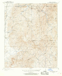
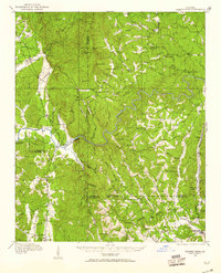
(34)- 1911 Map of Ellijay
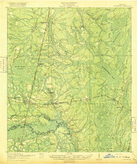
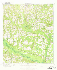
 1911 Ellijay1911 Print · USGSNorth Georgia and the Tennessee border are captured here at the turn of the century, showing a mountain landscape of river ferries and early rail. Genealogists can locate family landmarks like Higdons Store, the Pisgah church, or crossings at Bakers Ferry and Shallow Ford.4 unique versions available
 - 1911 Map of Cohutta Mtn
 1911 Cohutta Mtn1911 Print · USGSThe Georgia-Tennessee borderlands in the early twentieth century were defined by mountain rail and timber. Genealogists can trace family roots through settlements like Tennga and Crandall or locate historic operations like Hassler Mill along the rail line.2 unique versions available
 - 1912 Map of Milledgeville
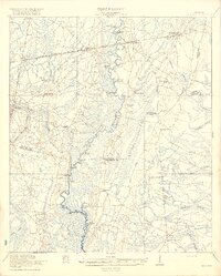
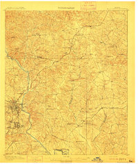 1912 Milledgeville1912 Print · USGSMilledgeville and its surroundings at the start of the century show a landscape shaped by state institutions and an expanding rail network. Researchers can trace the extensive State Sanitarium grounds or locate rural landmarks like Coleman Mill and Griffin Academy.3 unique versions available
 - 1912 Map of Mc Cormick, 1913 Print
 1912 Mc Cormick1913 Print · USGSThe Georgia and South Carolina borderlands come alive in the 1890s, centered on the rail junction at Mc Cormick and the Savannah River. Genealogists can trace family footprints across numerous river crossings like Fury Ferry and through rural centers such as Appling and Sharon Church.
 - 1913 Map of Cohutta Mtn.
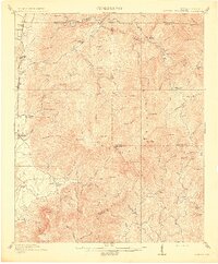 1913 Cohutta Mtn.1913 Print · USGSThe Georgia and Tennessee borderlands appear here in the years before the Great Depression, centered on the high peaks of the Blue Ridge. Researchers can trace early railroad life along the Louisville & Nashville RR or locate old sites like Cohutta Springs and Hassler Mill.3 unique versions available
 - 1914 Map of Seale
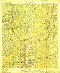
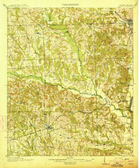 1914 Seale1914 Print · USGSRussell County's agricultural and railroad landscape is meticulously documented just before the First World War. Genealogists can trace family connections through local landmarks like Kite School, the community of Sand Fort, and historical river crossings like Perrys Ford.6 unique versions available
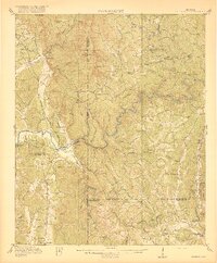
 - 1914 Map of Talking Rock, 1960 Print
 1914 Talking Rock1960 Print · USGSThe foothills of North Georgia are captured here before the mid-century, showing the early communities of Talking Rock and Whitestone along the Louisville and Nashville rail line. Researchers can trace family sites at Ball Creek School, locate river crossings like McClouds Ford, and follow the historic FEDERAL ROAD.2 unique versions available
 - 1916 Map of Talking Rock
 1916 Talking Rock1916 Print · USGSNorth Georgia in the years before the Great War is defined by the winding Coosawattee River and the historic Federal Road. Genealogists can trace family landmarks like Cairns Mill, Clouds Ford, and the old Ball Creek School.2 unique versions available
 - 1916 Map of Irwinton, 1963 Print
 1916 Irwinton1963 Print · USGSWilkinson County is captured here in the years before the Great War, showing a network of rural settlements connected by the Central of Georgia railroad. Genealogists can trace family landmarks and community centers like Goldens Mill, Hazelino School, and Toomsboro.2 unique versions available
 - 1917 Map of Nahunta, 1958 Print
 1917 Nahunta1958 Print · USGSSoutheast Georgia's riverine and rail networks are preserved here during the early twentieth century. Researchers can trace the legacy of rural education and transport through Ammons Ferry Bridge, the Jacksonville Post Road, and community anchors like Bixley Chapel.2 unique versions available
 - 1917 Map of Boulogne, 1966 Print
 1917 Boulogne1966 Print · USGSCoastal Georgia and Florida meet at the turn of the century along the winding banks of the Satilla and St Marys Rivers. Genealogists can trace family roots through numerous river landings like Gum Stump Landing and old community hubs such as Owens Ferry and Colerain.
 - 1917 Map of Macclenny, 1967 Print
 1917 Macclenny1967 Print · USGSThe Florida-Georgia borderlands come to life in the years before the Great War, showing the rail junctions and river crossings that shaped Baker County. Genealogists can trace family roots through numerous local landmarks like Sings Still, Macedon Church, and Garrett School.
 - 1918 Map of St Marys
 1918 St Marys1918 Print · USGSCoastal Nassau County and the Georgia border are seen here just after the Great War, during a period of peak railroad expansion. Trace family roots and old landings at St Marys, Wild's Ferry, and the Evergreen School house.
 - 1918 Map of Cumberland Island
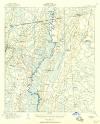
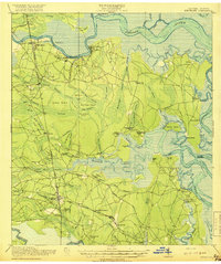
 1918 Cumberland Island1918 Print · USGSCoastal Georgia at the end of the Great War was a world of secluded island estates and vital maritime waterways. Researchers can trace the early infrastructure of the barrier islands through labels like Greyfield, the Lighthouse (Abandoned), and Plum Orchard Wharf.
 - 1918 Map of Jesup
 1918 Jesup1918 Print · USGSWayne County was a bustling rail and river corridor during the First World War era. Genealogists can trace family roots through a dense network of local landmarks, from Millikin Crossing School to the rural Bethlehem Church and Midway Church.3 unique versions available
 - 1918 Map of Folkston
 1918 Folkston1918 Print · USGSSoutheast Georgia and the Florida borderlands are captured here during the height of the regional timber and rail era. Genealogists can trace family footprints at Traders Hill, old schools like Davis School, and the early rail stations at Uptonville and Mattox.3 unique versions available
 - 1918 Map of Hortense
 1918 Hortense1918 Print · USGSSoutheast Georgia during the Great War era reveals a landscape shaped by river systems and steam-age railroads. Genealogists can trace family roots through numerous rural landmarks like Pendarvis School, Mt Zion Church, and the river crossing at Rosin Landing.2 unique versions available
 - 1918 Map of Hinesville
 1918 Hinesville1918 Print · USGSCoastal Liberty County is seen here during World War I, when a network of swamp-skirting roads connected small farming hubs and rail depots. Family historians can trace the exact locations of many rural institutions, including the Liberty Campmeeting Ground, New Jerusalem Church, and Ways Millpond.4 unique versions available
 - 1918 Map of Moniac
 1918 Moniac1918 Print · USGSThe borderlands of Georgia and Florida come alive in this 1917 survey of the Okeefenokee fringe and the St. Marys River. Researchers can trace the railroad economy through St George and Moniac, or locate family sites like Olivers Mill and the Chesser School.2 unique versions available
 - 1918 Map of Everett City
 1918 Everett City1918 Print · USGSCoastal Georgia at the end of the Great War was a world of vast river swamps and emerging rail junctions. Genealogists and historians can trace family locations through isolated landmarks like Bull Island School, the Ft Barrington Ferry, and the timber-driven siding at Thalmann.2 unique versions available
 - 1918 Map of Nahunta
 1918 Nahunta1918 Print · USGSSoutheastern Georgia at the end of the Great War reveals a landscape defined by the winding Satilla River and its vast swamps. Researchers can locate early schools and river crossings like Ammons Ferry Bridge, Oak Grove School, and Bixley Chapel.2 unique versions available
 - 1918 Map of Bladen
 1918 Bladen1918 Print · USGSThe Georgia coast at the end of the Great War reveals a landscape of tidal marshes and vital rail junctions. Genealogists can trace family roots through sites like Brockington School, Dover Bluff, and the junction at Bladen.2 unique versions available
 - 1918 Map of Kingsland
 1918 Kingsland1918 Print · USGSCamden County, Georgia, at the Florida border, is shown here during the First World War era when river landings and rail junctions shaped local life. Genealogists can trace family footprints at Ruhamah School, Fairview Church, and the riverfront settlement of Ceylon.3 unique versions available
 - 1918 Map of Macclenny
 1918 Macclenny1918 Print · USGSThe Florida-Georgia borderlands come to life in this World War I-era survey of the pine flatwoods and river prongs. Researchers can trace early family sites like Macclenny and Glen St Mary, alongside rural landmarks such as Hicks Church and Suggs Still.4 unique versions available
 - 1918 Map of Oliver, 1972 Print
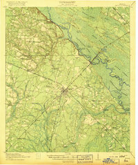
 1918 Oliver1972 Print · USGSScreven County at the end of the Great War was a landscape defined by its river landings and intersecting railroads. Genealogists can trace family footprints at dozens of rural landmarks, from Lee Memorial Church and Jackson School to the depots in Oliver and Newington.
Showing maps 1-25 of 34
Top cities of Georgia
- Atlanta historical maps
- Augusta historical maps
- Columbus historical maps
- Macon historical maps
- Savannah historical maps
- Athens historical maps
See more
Top counties of Georgia
- Fulton County historical maps
- Gwinnett County historical maps
- Cobb County historical maps
- DeKalb County historical maps
- Chatham County historical maps
- Clayton County historical maps
See more
Frequently asked questions
- What are the different types of historical maps available for Georgia?
- What is the oldest map of Georgia?
- Where can I purchase historical maps of Georgia for my home or office?
- Where can I download high-res historical maps of Georgia?
- Are there historical topographic maps available for Georgia?
- Is there historical aerial imagery available for Georgia?
- Where are historical maps of Georgia sourced from?