1910s Maps of North Dakota
Explore 10 historic maps of North Dakota from the 1910s. These maps offer a rare glimpse into what life looked like during the 1910s — showing old roads, neighborhoods, homes, and landmarks that have changed or disappeared over time.
Whether you're researching your family's past, planning a metal detecting trip, or studying how North Dakota's landscape evolved across the 1910s, these high-resolution maps are a powerful tool for exploring the history of this region.
- Focus on a specific era: All maps on this page are from the 1910s, giving you a focused view of this time period.
- See what’s changed: Compare century-old streets, trails, and buildings to today's modern landscape using overlays and satellite layers.
- Research with precision: Use these maps for genealogy, historical research, land use analysis, or educational projects.
- View, download, or print: Maps are fully viewable online in high resolution, and can be downloaded or printed for your own records.
Start exploring North Dakota's history through authentic maps from the 1910s. This is your window into the past.
North Dakota maps
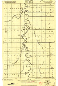
(10)- 1911 Map of Ray
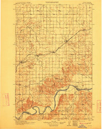 1911 Ray1911 Print · USGSNorthwest North Dakota at the height of the homesteading era reveals a landscape defined by the iron rails and the wide Missouri. Genealogists and researchers can trace the early rail stops like Wheelock and Epping or locate river landmarks such as Nesson Ferry and Banks.2 unique versions available
 - 1915 Map of White Rock, 1954 Print
 1915 White Rock1954 Print · USGSThe tri-state border region of the Dakotas and Minnesota comes alive in the early twentieth century as a hub of rail lines and prairie schools. Trace early settlements like White Rock and Rosholt or locate family landmarks such as Knutson School and Teare School.2 unique versions available
 - 1917 Map of New Effington
 1917 New Effington1917 Print · USGSThe Dakota borderlands come alive in this survey from the mid-1910s, capturing the early rail-and-reservation era. Genealogists can locate family-named landmarks like Shafts School and Wymen School along the Minneapolis St Paul and Sault Ste Marie line.2 unique versions available
 - 1918 Map of Kelso
 1918 Kelso1918 Print · USGSTraill County’s prairie landscape is captured here just after the Great War, showing a highly organized grid of rail towns and township schools. Genealogists can locate family roots near Blanchard, Kelso, or the Town Hall in Norway.
 - 1918 Map of La Moure
 1918 La Moure1918 Print · USGSSoutheastern North Dakota was a thriving rail and agricultural hub during the early twentieth century, as seen in this detailed 1918 survey. Researchers can trace the development of the James River corridor and locate early settlements like Grand Rapids, Oakes, and Port Emma.2 unique versions available
 - 1918 Map of Hendrum
 1918 Hendrum1918 Print · USGSThe Red River Valley borderlands are captured here just before the end of the Great War, showing the vital rail and river corridor between North Dakota and Minnesota. Researchers can trace the early footprints of Shelly Station, Halstad Station, and Hendrum Station along the Great Northern railroad.
 - 1918 Map of White Rock
 1918 White Rock1918 Print · USGSThe tri-state borderlands of South Dakota, Minnesota, and North Dakota are frozen in time just before the end of the Great War. Researchers can trace the Sisseton and Wahpeton Indian Reservation boundary or locate early schools like Teare School and Knutson School.4 unique versions available
 - 1918 Map of Walhalla
 1918 Walhalla1918 Print · USGSThe North Dakota borderlands come into focus at the end of the Great War, showing a landscape of pioneer townships and river valleys. Genealogists can trace family footprints near Walhalla and Beaulieu, or locate long-standing rural Schools and the Great Northern R.R. line.
 - 1918 Map of Acton
 1918 Acton1918 Print · USGSThe Red River Valley's winding borderlands are captured here during the First World War, showing the transition from wild wetlands to managed farmland. Genealogists can trace small settlements and rural schoolhouses like Acton, Bigwoods, and St. Andrews.
 - 1919 Map of Eldred
 1919 Eldred1919 Print · USGSThe Red River Valley at the end of the Great War shows a landscape of grain elevators and riverfront settlements. Genealogists can locate family landmarks across Vineland, Sidney, and Hubbard, including Station Eldred and the Climax tall Elevator.
End of results
Showing maps 1-10 of 10
Top cities of North Dakota
- Fargo historical maps
- Bismarck historical maps
- Grand Forks historical maps
- West Fargo historical maps
- Minot historical maps
- Williston historical maps
See more
Top counties of North Dakota
- Cass County historical maps
- Burleigh County historical maps
- Ward County historical maps
- Grand Forks County historical maps
- Williams County historical maps
- Stark County historical maps
See more
Frequently asked questions
- What are the different types of historical maps available for North Dakota?
- What is the oldest map of North Dakota?
- Where can I purchase historical maps of North Dakota for my home or office?
- Where can I download high-res historical maps of North Dakota?
- Are there historical topographic maps available for North Dakota?
- Is there historical aerial imagery available for North Dakota?
- Where are historical maps of North Dakota sourced from?