2000-2009 Maps of North Dakota
Explore 2 historic maps of North Dakota from 2000-2009. These maps offer a rare glimpse into what life looked like during the 2000s — showing old roads, neighborhoods, homes, and landmarks that have changed or disappeared over time.
Whether you're researching your family's past, planning a metal detecting trip, or studying how North Dakota's landscape evolved across the 2000s, these high-resolution maps are a powerful tool for exploring the history of this region.
- Focus on a specific era: All maps on this page are from the 2000s, giving you a focused view of this time period.
- See what’s changed: Compare century-old streets, trails, and buildings to today's modern landscape using overlays and satellite layers.
- Research with precision: Use these maps for genealogy, historical research, land use analysis, or educational projects.
- View, download, or print: Maps are fully viewable online in high resolution, and can be downloaded or printed for your own records.
Start exploring North Dakota's history through authentic maps from the 2000s. This is your window into the past.
North Dakota maps
(2)- 2005 Map of Eagles Nest Butte, 2007 Print
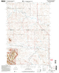 2005 Eagles Nest Butte2007 Print · USGSThe North Dakota and South Dakota borderlands meet here in the early twenty-first century, revealing a landscape of high plains ranching and national forest. Genealogists and local historians can locate the Feist Ranch, trace the Bullock Road, and find the sites of the Lone Tree School and Cox School.
 - 2005 Map of Ladner NE, 2007 Print
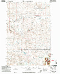 2005 Ladner NE2007 Print · USGSThe borderlands of South Dakota and North Dakota are documented here in the early 2000s, showing a high plains landscape of ranching and national forest. Genealogists and local historians can locate the Grand River Sch, Cox Ch, and family landmarks like Janvrin Ranch.
End of results
Showing maps 1-2 of 2
Top cities of North Dakota
- Fargo historical maps
- Bismarck historical maps
- Grand Forks historical maps
- West Fargo historical maps
- Minot historical maps
- Williston historical maps
See more
Top counties of North Dakota
- Cass County historical maps
- Burleigh County historical maps
- Ward County historical maps
- Grand Forks County historical maps
- Williams County historical maps
- Stark County historical maps
See more
Frequently asked questions
- What are the different types of historical maps available for North Dakota?
- What is the oldest map of North Dakota?
- Where can I purchase historical maps of North Dakota for my home or office?
- Where can I download high-res historical maps of North Dakota?
- Are there historical topographic maps available for North Dakota?
- Is there historical aerial imagery available for North Dakota?
- Where are historical maps of North Dakota sourced from?