1920s Maps of North Dakota
Explore 10 historic maps of North Dakota from the 1920s. These maps offer a rare glimpse into what life looked like during the 1920s — showing old roads, neighborhoods, homes, and landmarks that have changed or disappeared over time.
Whether you're researching your family's past, planning a metal detecting trip, or studying how North Dakota's landscape evolved across the 1920s, these high-resolution maps are a powerful tool for exploring the history of this region.
- Focus on a specific era: All maps on this page are from the 1920s, giving you a focused view of this time period.
- See what’s changed: Compare century-old streets, trails, and buildings to today's modern landscape using overlays and satellite layers.
- Research with precision: Use these maps for genealogy, historical research, land use analysis, or educational projects.
- View, download, or print: Maps are fully viewable online in high resolution, and can be downloaded or printed for your own records.
Start exploring North Dakota's history through authentic maps from the 1920s. This is your window into the past.
North Dakota maps
(10)- 1922 Map of Garrison
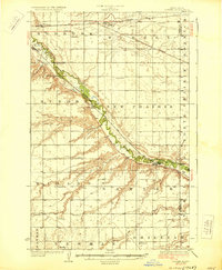
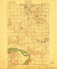 1922 Garrison1922 Print · USGSIn the early 1920s, McLean County was a landscape of steam-powered transit and scattered prairie schoolhouses. Researchers can trace the original Soo Line rail corridor and locate rural landmarks like Ireland School, Baker School, and the winding Snake Creek valley.2 unique versions available
 - 1925 Map of Edgeley
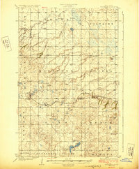
 1925 Edgeley1925 Print · USGSLaMoure and Dickey Counties are shown in the mid-1920s as a complex network of rail lines and prairie townships. Trace the early layout of Ellendale, the historical Whitestone Battlefield Park, and rail stops at Deisem and Medberry.2 unique versions available
 - 1926 Map of Ardoch, 1944 Print
 1926 Ardoch1944 Print · USGSWalsh and Grand Forks Counties at the peak of the rail era show a landscape shaped by steam and drainage. Trace the routes of three major railroads through Ardoch, find country schools, and locate early crossings like Public Xing.-865 and the Cem. near Forest River.
 - 1928 Map of Minot
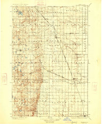
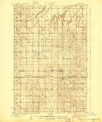
 1928 Minot1928 Print · USGSThe growing rail hub of Minot emerges along the Souris River valley in the mid-1920s. Genealogists and historians can trace numerous rural schools across townships like Burt and Nedrose, alongside early rail sidings at Drady and Stringtown.3 unique versions available
 - 1928 Map of Tokio, 1954 Print
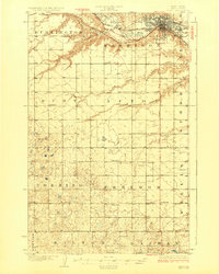
 1928 Tokio1954 Print · USGSThe Devils Lake Indian Reservation and the shores of Devils Lake are captured here in the late 1920s. Genealogists and local historians can trace the Great Northern rail line through Tokio or locate rural landmarks like Wood Lake Ch and Fort Totten P O.
 - 1929 Map of Sawyer
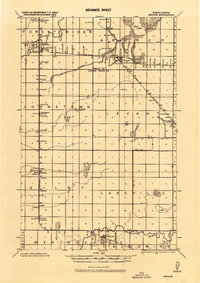
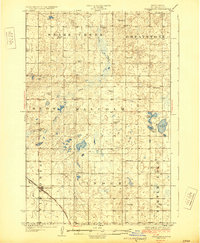
 1929 Sawyer1929 Print · USGSWard County's prairie and river valleys are captured here in the late 1920s as the rail-and-river economy flourished. Genealogists can trace rural school districts like School No 2 and School No 3 or locate early river crossings such as the Saugstad Bridge.2 unique versions available
 - 1929 Map of Coleharbor
 1929 Coleharbor1929 Print · USGSMcLean County townships are shown here during the late 1920s as the rail network solidified the region's agricultural economy. Genealogists and local historians can locate early prairie schoolhouses like Fisher Sch and trace the original route of the Minneapolis St Paul and Sault Ste Marie railroad.3 unique versions available
 - 1929 Map of Benedict
 1929 Benedict1929 Print · USGSThe North Dakota prairie near the McLean and Ward county line is captured here in the late twenties, centered on the rail-stop of Benedict. Researchers can locate numerous early schoolhouses and trace the path of the Minneapolis St Paul and Sault Ste Marie through Poplar and Greeley.3 unique versions available
 - 1929 Map of Kongsberg
 1929 Kongsberg1929 Print · USGSThe North Dakota prairie near the McHenry and McLean county line is shown here in the late twenties as a network of rail-bound villages and rural schools. You can trace the Soo Line railroad to Kongsberg or locate family-named landmarks like Woodhill Sch and Dogden Butte.2 unique versions available
 - 1929 Map of Balfour
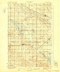 1929 Balfour1929 Print · USGSNorth Dakota's central plains in the late twenties reveal a landscape of homesteads and rail towns along the Minneapolis St Paul and Sault Ste Marie. Genealogists can locate rural schoolhouses like Fleming School and trace the shores of Cottonwood Lake or Krueger Lake.
End of results
Showing maps 1-10 of 10
Top cities of North Dakota
- Fargo historical maps
- Bismarck historical maps
- Grand Forks historical maps
- West Fargo historical maps
- Minot historical maps
- Williston historical maps
See more
Top counties of North Dakota
- Cass County historical maps
- Burleigh County historical maps
- Ward County historical maps
- Grand Forks County historical maps
- Williams County historical maps
- Stark County historical maps
See more
Frequently asked questions
- What are the different types of historical maps available for North Dakota?
- What is the oldest map of North Dakota?
- Where can I purchase historical maps of North Dakota for my home or office?
- Where can I download high-res historical maps of North Dakota?
- Are there historical topographic maps available for North Dakota?
- Is there historical aerial imagery available for North Dakota?
- Where are historical maps of North Dakota sourced from?