1900-1909 Maps of North Dakota
Explore 6 historic maps of North Dakota from 1900-1909. These maps offer a rare glimpse into what life looked like during the 1900s — showing old roads, neighborhoods, homes, and landmarks that have changed or disappeared over time.
Whether you're researching your family's past, planning a metal detecting trip, or studying how North Dakota's landscape evolved across the 1900s, these high-resolution maps are a powerful tool for exploring the history of this region.
- Focus on a specific era: All maps on this page are from the 1900s, giving you a focused view of this time period.
- See what’s changed: Compare century-old streets, trails, and buildings to today's modern landscape using overlays and satellite layers.
- Research with precision: Use these maps for genealogy, historical research, land use analysis, or educational projects.
- View, download, or print: Maps are fully viewable online in high resolution, and can be downloaded or printed for your own records.
Start exploring North Dakota's history through authentic maps from the 1900s. This is your window into the past.
North Dakota maps
(6)- 1900 Map of Pingree
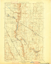 1900 Pingree1900 Print · USGSStutsman and Foster counties come alive in the final years of the nineteenth century as railroads began to stitch together the vast prairie. Researchers can trace the early rail stops at Pingree, Kensal, and Buchanan alongside the waters of Jim Lake and Spiritwood Lake.2 unique versions available
 - 1900 Map of Pingree, 1949 Print
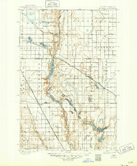 1900 Pingree1949 Print · USGSNorth Dakota's prairie landscape was being rapidly transformed by rail and river at the end of the 19th century. Researchers can trace early township development and rail stops like Pingree, Kensal, and Buchanan along the James River and Arrowwood Lake.
 - 1904 Map of Wahpeton
 1904 Wahpeton1904 Print · USGSThe Red River Valley at the start of the century was a landscape of burgeoning rail towns and river commerce along the Minnesota border. Genealogists can trace early homesteads and transport hubs between Wahpeton and Breckenridge, or follow the rail lines through Hankinson and Abercrombie.2 unique versions available
 - 1907 Map of Bismarck
 1907 Bismarck1907 Print · USGSThe Missouri River corridor at the turn of the century shows North Dakota's capital and rail hubs in their formative years. Researchers can trace early land divisions and transport routes like the Fort Yates Stage Road and landmarks such as Fort Lincoln or St Anthony.2 unique versions available
 - 1907 Map of Wyndmere
 1907 Wyndmere1907 Print · USGSRichland and Sargent counties are seen here in the early 1900s during the height of the prairie railroad boom. Genealogists and historians can trace the paths of five different rail lines serving early towns like Milnor, Wyndmere, and Sandoun Mc Leod P O.2 unique versions available
 - 1909 Map of Glendive
 1909 Glendive1909 Print · USGSThe confluence of the Missouri and Yellowstone rivers in the first decade of the twentieth century shows a region of scattered ranches and emerging river towns. Genealogists can trace family landmarks like Cavanaughs Ranch or Nortons Ranch and find early resource sites like the Coal Mine.
End of results
Showing maps 1-6 of 6
Top cities of North Dakota
- Fargo historical maps
- Bismarck historical maps
- Grand Forks historical maps
- West Fargo historical maps
- Minot historical maps
- Williston historical maps
See more
Top counties of North Dakota
- Cass County historical maps
- Burleigh County historical maps
- Ward County historical maps
- Grand Forks County historical maps
- Williams County historical maps
- Stark County historical maps
See more
Frequently asked questions
- What are the different types of historical maps available for North Dakota?
- What is the oldest map of North Dakota?
- Where can I purchase historical maps of North Dakota for my home or office?
- Where can I download high-res historical maps of North Dakota?
- Are there historical topographic maps available for North Dakota?
- Is there historical aerial imagery available for North Dakota?
- Where are historical maps of North Dakota sourced from?