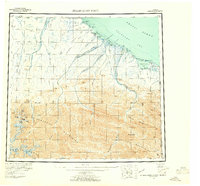
1955 Map of Demarcation Point
USGS Topo · Published 1961About this map
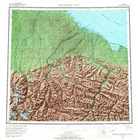
Demarcation Point and the adjacent Demarcation Bay sit at the northeastern edge of the Alaskan Arctic, where the Alaska Yukon boundary meets the Beaufort Sea. This 1950s survey documents a landscape of coastal lagoons and braided river deltas, including the Kongakut River and Aichilik River, as they descend from the Romanzof Mountains and British Mountains. Cultural features are sparse, limited to coastal sites such as Gordon and former settlements like Kulukruak and Kagiluak. The map provides a detailed view of the offshore barrier features like Icy Reef and numerous points such as Humphrey Pt and Nuvagapak Pt. Inland, the terrain is dominated by the northern reaches of the Brooks Range, with prominent peaks including Marie Mountain and Mt Greenough overlooking the remote Arctic drainage systems.
Find a feature on this map
61 named features on this map. Tap any name to fly to it.
Don’t see what you’re looking for? This feature index may not catch every label — zoom into the map to look around manually.
Map Details
Editions of this 1955 Demarcation Point Map
8 editions found
Other maps of this area

1951 · Barter Island
USGS Topo · 1:250,000

1951 · Demarcation Point
USGS Topo · 1:250,000

1951 · Arctic
USGS Topo · 1:250,000

1951 · Table Mountain
USGS Topo · 1:250,000

1951 · Mt. Michelson
USGS Topo · 1:250,000

1955 · Flaxman Island
USGS Topo · 1:250,000

1955 · Demarcation Point
USGS Topo · 1:250,000

1955 · Mount Michelson B-1
USGS Topo · 1:63,360

1955 · Mount Michelson C-1
USGS Topo · 1:63,360

1955 · Demarcation Point C-5
USGS Topo · 1:63,360