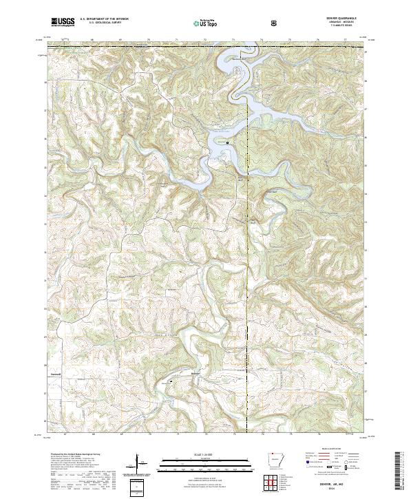
2024 Map of Denver
USGS Topo · Published 2024About this map
The settlement of Denver serves as a central hub in this section of Carroll County, located near the confluence of Callens Branch and Long Creek. To the west, the village of Farewell sits along the roadway, while the landscape to the north is defined by the deep inlets of Table Rock Lake. The terrain is deeply incised by a network of named hollows, including Tereherst Hollow and May Hollow, which drain toward the primary creek beds. High elevations are marked by distinctive landmarks such as Backbone Bluff and Kimhowart Hill. Local genealogy is well-supported by the presence of the Denver Cem and Enon Cem, which are situated along the winding rural county road system. A portion of the Mark Twain National Forest occupies the northwest corner, where South Fork Brush Creek enters the frame, illustrating the transition from managed forest to private agricultural and lakeside lands.
Find a feature on this map
95 named features on this map. Tap any name to fly to it.
Don’t see what you’re looking for? This feature index may not catch every label — zoom into the map to look around manually.
Map Details
Editions of this 2024 Denver Map
This is the sole edition of this map. No revisions or reprints were ever made.
Other maps of this area

1904 · Harrison
USGS Topo · 1:125,000

1905 · Harrison
USGS Topo · 1:125,000

1907 · Forsyth
USGS Topo · 1:125,000

1945 · Harrison
USGS Topo · 1:250,000

1949 · Harrison
USGS Topo · 1:250,000

1954 · Harrison
USGS Topo · 1:250,000

1956 · Lampe
USGS Topo · 1:24,000

1956 · Table Rock Dam
USGS Topo · 1:24,000
1956 · Hollister
USGS Topo · 1:24,000

1958 · Harrison
USGS Topo · 1:250,000