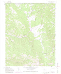
1963 Map of Mc Carty Park
USGS Topo · Published 1982About this map
The Sangre De Cristo Range dominates this 1963 survey of the Colorado high country, where the borders of Costilla and Huerfano counties meet. At the northern edge, the Denver and Rio Grande Western railroad crosses through Veta Pass, a critical mountain transit point. The landscape is characterized by high alpine parks and deep drainage systems, including Mc Carty Park and Elk Park. Evidence of early cattle ranching and mountain transit is visible at Mc Carty's Cow Camp, located along an old Wagon Road near the headwaters of the North Fork Trinchera Creek. In the south, the settlement of Dodgeton sits near Bennett Creek, while prominent summits like Harrison Peak and Napoleon Peak tower over the San Isabel National Forest.
Find a feature on this map
33 named features on this map. Tap any name to fly to it.
Don’t see what you’re looking for? This feature index may not catch every label — zoom into the map to look around manually.
Map Details
Editions of this 1963 Mc Carty Park Map
5 editions found
Other maps of this area

1889 · Huerfano Park
USGS Topo · 1:125,000

1892 · Huerfano Park
USGS Topo · 1:125,000

1954 · Trinidad
USGS Topo · 1:250,000

1955 · Trinidad
USGS Topo · 1:250,000

1958 · Trinidad
USGS Topo · 1:250,000

1959 · Trinidad
USGS Topo · 1:250,000

1963 · Mc Carty Park
USGS Topo · 1:24,000

1963 · La Veta Pass
USGS Topo · 1:24,000
1963 · La Veta
USGS Topo · 1:24,000
1963 · Cuchara
USGS Topo · 1:24,000