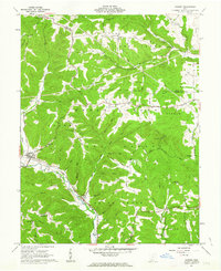
1961 Map of Rarden
USGS Topo · Published 1963About this map
The Brush Creek State Forest dominates this section of Scioto County, where deep ridges and narrow hollows dictate the layout of small settlements like Rarden and Mt Joy. During the early 1960s, the Norfolk and Western railway tracked the winding course of Scioto Brush Creek, providing a vital transportation corridor through the dense terrain. The map is particularly valuable for genealogists, documenting numerous family-named landmarks and burial sites such as Old Hackworth Cem, Staley Cem, and Hoffer Hill Cem.
Find a feature on this map
67 named features on this map. Tap any name to fly to it.
Don’t see what you’re looking for? This feature index may not catch every label — zoom into the map to look around manually.
Map Details
Editions of this 1961 Rarden Map
4 editions found
Other maps of this area

1915 · Bainbridge
USGS Topo · 1:48,000

1915 · Otway
USGS Topo · 1:62,500

1915 · Piketon
USGS Topo · 1:62,500

1916 · Peebles
USGS Topo · 1:62,500

1917 · Bainbridge
USGS Topo · 1:62,500

1917 · Piketon
USGS Topo · 1:62,500

1917 · Otway
USGS Topo · 1:62,500

1918 · Peebles
USGS Topo · 1:62,500

1944 · Piketon
USGS Topo · 1:62,500

1947 · Columbus
USGS Topo · 1:250,000