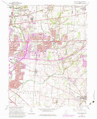
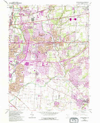
1964 Map of Reynoldsburg
USGS Topo · Published 1974About this map
Reynoldsburg and the eastern edge of Columbus define this mid-century landscape during a period of significant suburban expansion. The 1973 photorevisions, shown in purple, illustrate the rapid transformation of farmland into residential developments and shopping centers, particularly around Whitehall and the Port Columbus International Airport. Despite this growth, older rural foundations remain visible through family-named landmarks like Truro Cem and Hockman Cem, alongside established rail lines such as the Penn Central and Baltimore and Ohio.
Find a feature on this map
48 named features on this map. Tap any name to fly to it.
Don’t see what you’re looking for? This feature index may not catch every label — zoom into the map to look around manually.
Map Details
Editions of this 1964 Reynoldsburg Map
5 editions found
Other maps of this area

1902 · Westerville
USGS Topo · 1:62,500

1904 · Westerville
USGS Topo · 1:62,500

1907 · Thurston
USGS Topo · 1:62,500

1908 · Granville
USGS Topo · 1:62,500

1909 · Thurston
USGS Topo · 1:62,500

1910 · Granville
USGS Topo · 1:62,500

1925 · East Columbus
USGS Topo · 1:62,500

1943 · East Columbus
USGS Topo · 1:62,500

1947 · Columbus
USGS Topo · 1:250,000

1950 · Marion
USGS Topo · 1:250,000