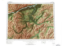
1952 Map of Ruby
USGS Topo · Published 1973About this map
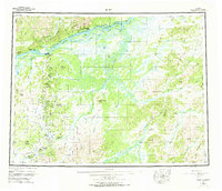
The Yukon River carves through the northern reach of this interior landscape, serving as the primary artery for remote outposts like Ruby. This 1952 survey, updated with revisions in the early 1970s, documents a network of interior settlements and transport routes essential to the region's mining and trapping history. A prominent Winter Trail connects the riverside with southern outposts, passing through Sulatna Crossing toward the mining areas around Poorman and Placerville. The terrain is defined by the massive drainage of the Nowitna River and Sulatna River, which wind through the Monzonite Hills and Kokrines Hills. These waterways and their associated landing strips, such as the Poorman Landing Area, highlight the reliance on seasonal transport and small aircraft in the Alaskan bush. Distinctive landmarks like Yuki Mountain, Monument Rocks, and Twin Buttes provide essential navigation points across the vast, rolling highlands south of the Yukon.
Find a feature on this map
42 named features on this map. Tap any name to fly to it.
Don’t see what you’re looking for? This feature index may not catch every label — zoom into the map to look around manually.
Map Details
Editions of this 1952 Ruby Map
8 editions found

Other maps of this area

1945 · Nulato
USGS Topo · 1:250,000

1948 · Kantishna River
USGS Topo · 1:250,000

1950 · Medfra
USGS Topo · 1:250,000

1951 · Ophir
USGS Topo · 1:250,000

1951 · Nulato
USGS Topo · 1:250,000

1951 · Kantishna River
USGS Topo · 1:250,000

1951 · Ruby
USGS Topo · 1:250,000

1951 · Kateel River
USGS Topo · 1:250,000

1951 · Melozitna
USGS Topo · 1:250,000

1951 · Tanana
USGS Topo · 1:250,000