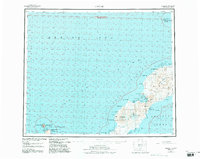
1951 Map of Umnak
USGS Topo · Published 1984About this map
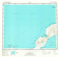
Mt Vsevidof and Mt Recheshnoi dominate the central volcanic backbone of Umnak Island, where the landscape transitions from these massive peaks to the collapsed maw of the Okmok Caldera in the northeast. This coastal and geological survey captures the remote Aleutian environment before late-century shifts, documenting geothermal features like Geyser Bight and Hot Springs Cove along the shores of Inanudak Bay. A solitary Cemetery is marked near the coast, providing a rare trace of human presence amidst the broader Aleutian Islands Wilderness. To the north, the isolated Bogoslof Wilderness encompasses Bogoslof Island and Fire Island, while the southwestern waters are dotted by the Islands of Four Mountains, including Kagamil Island and Uliaga Island. The map meticulously details the island's perimeter, from the jagged The Pillars to the shelter of Russian Bay.
Find a feature on this map
51 named features on this map. Tap any name to fly to it.
Don’t see what you’re looking for? This feature index may not catch every label — zoom into the map to look around manually.
Map Details
Editions of this 1951 Umnak Map
8 editions found
Other maps of this area

1951 · Unalaska
USGS Topo · 1:250,000

1951 · Amukta
USGS Topo · 1:250,000

1951 · Samalga Island
USGS Topo · 1:250,000

1951 · Umnak
USGS Topo · 1:250,000

1958 · Samalga Island
USGS Topo · 1:250,000

1958 · Umnak
USGS Topo · 1:250,000
2021 · Samalga Island D-6 OE E NW
USGS Topo · 1:25,000
2021 · Samalga Island D-4 NW
USGS Topo · 1:25,000
2021 · Umnak A-2 NW
USGS Topo · 1:25,000
2021 · Umnak A-2 NE
USGS Topo · 1:25,000