1900s (20th Century) Maps of Montana
Explore 4,356 historic maps of Montana from the 1900s (20th Century). These maps offer a rare glimpse into what life looked like during the 1900s — showing old roads, neighborhoods, homes, and landmarks that have changed or disappeared over time.
Whether you're researching your family's past, planning a metal detecting trip, or studying how Montana's landscape evolved across the 1900s, these high-resolution maps are a powerful tool for exploring the history of this region.
- Focus on a specific era: All maps on this page are from the 1900s, giving you a focused view of this time period.
- See what’s changed: Compare century-old streets, trails, and buildings to today's modern landscape using overlays and satellite layers.
- Research with precision: Use these maps for genealogy, historical research, land use analysis, or educational projects.
- View, download, or print: Maps are fully viewable online in high resolution, and can be downloaded or printed for your own records.
Start exploring Montana's history through authentic maps from the 1900s. This is your window into the past.
Montana maps
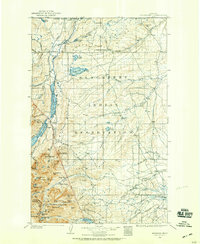
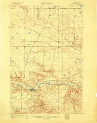
(4,356)- 1901 Map of Hamilton
 1901 Hamilton1901 Print · USGSThe Bitterroot Valley in the late nineteenth century is a landscape of emerging rail towns and sophisticated irrigation. Trace the development of early Hamilton and Victor alongside the Northern Pacific Railway and historic canals like Republican Ditch.6 unique versions available
 - 1901 Map of Rosebud
 1901 Rosebud1901 Print · USGSSouthern Montana ranching and rail life are documented here during the final decade of the nineteenth century. Genealogists and historians can trace early holdings like Yellow Weasel Ranch and Sand Hills Ranch along the Burlington and Missouri River R. R.4 unique versions available
 - 1901 Map of Canyon
 1901 Canyon1901 Print · USGSYellowstone's northeast wilderness appears at the dawn of the twentieth century, detailing the park's early infrastructure and raw geothermal wonders. Researchers can trace the original locations of Yanceys, Baronett Bridge, and unique curiosities like the Fossil Forest.
 - 1901 Map of Dayton
 1901 Dayton1901 Print · USGSSheridan County and the Montana borderlands are captured here at the turn of the century as the railroad reshapes the valley. Researchers can trace early settlements and ranching outposts like Slack, Beckton, and the Morrow Ranch along the Tongue River.5 unique versions available
 - 1901 Map of St. Xavier
 1901 St. Xavier1901 Print · USGSBig Horn County at the turn of the century shows a frontier landscape shaped by military history and the early years of the Crow Reservation. Researchers can trace the path of the Old Bozeman Military Road past the Site of Old Fort C. F. Smith and the St. Xavier Mission.4 unique versions available
 - 1901 Map of Gallatin
 1901 Gallatin1901 Print · USGSThe high plateau of the Yellowstone country appears here in the late nineteenth century, just as its hydrothermal wonders were becoming globally known. Researchers can locate early campsites and lodges near the Norris Geyser Basin, Obsidian Cliff, and Mammoth Hot Springs.
 - 1901 Map of Coeur D'Alene District, 1954 Print
 1901 Coeur D'Alene District1954 Print · USGSIdaho's Silver Valley hums with industrial activity at the turn of the century as silver and lead mining reach their peak. Genealogists and historians can trace the deep-vein claims of the Bunker Hill and Sullivan Mine or the narrow-canyon settlements of Burke and Mace.
 - 1901 Map of Aladdin, 1954 Print
 1901 Aladdin1954 Print · USGSCrook County ranching and rail life at the turn of the century is preserved here, from the mountain slopes to the river valleys. Genealogists can trace early homesteads and shipping points like Aladdin, Beulah, and the VVV Ranch.
 - 1901 Map of Browning, 1959 Print
 1901 Browning1959 Print · USGSThe Blackfeet Indian Reservation and eastern Glacier National Park meet in this early twentieth-century survey. Genealogists and historians can trace old homesteads and landmarks like Galbreath Ranch, the Pontresina Sch, and the Great Northern rail corridor.
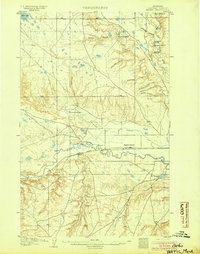
 - 1902 Map of Little Belt Mts.
 1902 Little Belt Mts.1902 Print · USGSMeagher County at the close of the nineteenth century is a landscape of mountain mining camps and riverside settlements. Researchers can trace early industry and family roots near the Sapphire Mine, the town of White Sulphur Springs, and the camp at Neihart.3 unique versions available
 - 1902 Map of Ovando, 1960 Print
 1902 Ovando1960 Print · USGSMontana's mountain ranchlands come into focus at the turn of the century, centered on the valley around Ovando. Genealogists and historians can trace numerous family homesteads and early outposts, including Danaher's Ranch, Woodworth, and Blanchard's Ranch.2 unique versions available
 - 1903 Map of Browning
 1903 Browning1903 Print · USGSThe Blackfeet Reservation and the high peaks of northern Montana appear here shortly after the turn of the century. You can trace the path of the Great Northern R. R. through Browning or locate early settlements like St. Mary along the glacial lakes.2 unique versions available
 - 1903 Map of Saypo
 1903 Saypo1903 Print · USGSTeton and Lewis and Clark counties appear at the dawn of the century as a landscape of remote mountain forest reserves and early prairie homesteads. Researchers can trace the holdings of pioneer families at Clark Bros Ranch and Campbell's Ranch or locate early industry at McGunks Sawmill and the local Coal Mine.7 unique versions available
 - 1903 Map of Coopers Lake
 1903 Coopers Lake1903 Print · USGSLewis and Clark and Powell counties are shown at the turn of the century as the high-mountain ranching and mining frontier expanded. Genealogists and researchers can locate family landmarks like Lunds Ranch, Witmer Bros Ranch, and the Klondike Mine.3 unique versions available
 - 1903 Map of Bonner
 1903 Bonner1903 Print · USGSMissoula and the surrounding river canyons come to life in this turn-of-the-century survey during the height of early rail expansion. Trace the original path of the Northern Pacific through mountain passes and locate early settlements like Bonner, Potomac, and Clinton.4 unique versions available
 - 1903 Map of Aladdin
 1903 Aladdin1903 Print · USGSThe northern Black Hills region at the turn of the century reveals a landscape defined by the arrival of the Wyoming and Missouri River R.R. and expansive cattle ranching. Researchers can trace the early footprints of settlements like Aladdin and Beulah, alongside established landmarks like the VVV Ranch and Schoolmarm Butte.3 unique versions available
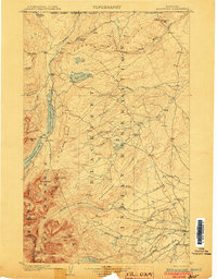
 - 1903 Map of Helena
 1903 Helena1903 Print · USGSMontana's mining heartland comes alive at the dawn of the new century, from the state capital to the copper-rich summits above the Silver Bow. Trace the early rail lines serving Marysville, locate the historic barracks of Ft. Harrison, and follow the mountain trails through Mullan Pass.4 unique versions available
 - 1903 Map of Coeur D'Alene District
 1903 Coeur D'Alene District1903 Print · USGSThe Silver Valley was at its industrial peak at the start of the century, defined by a dense network of silver and lead operations. Genealogists and historians can trace early rail lines and major works like the Standard Mines, Gem Mine, and the town of Wardner.
 - 1903 Map of Wayne Creek, 1958 Print
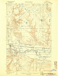
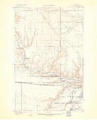
 1903 Wayne Creek1958 Print · USGSBlaine County was an open ranching landscape at the turn of the century, defined by the northern plains and the river valley corridor. Trace the early Great Plains rail economy at Montauk along the Great Northern RR and locate pioneer outposts like Nickols Ranch.
 - 1904 Map of Yantic
 1904 Yantic1904 Print · USGSNorthern Montana ranching life is frozen in time on this 1904 survey of the Milk River valley. Researchers can trace early homesteads like Potter's Ranch and Empire Ranch or follow the route of the Great Northern R. R. through Yantic.2 unique versions available
 - 1904 Map of Chinook
 1904 Chinook1904 Print · USGSLife in the Milk River Valley at the dawn of the century revolved around the rail lines and new irrigation canals. Researchers can trace early ranch holdings like Nelson's Ranch and Ronne's Ranch or locate the site of Kerrs Coalmine.2 unique versions available
 - 1904 Map of Havre
 1904 Havre1904 Print · USGSHavre and the Milk River valley are captured in this early century survey as the region transitioned from a frontier military outpost to a railroad-driven settlement. Researchers can trace the original locations of numerous family homesteads like Conley's Ranch and Mc Grew's Ranch, alongside the sprawling Fort Assinniboine Mil. Res..2 unique versions available
 - 1904 Map of Chief Mountain
 1904 Chief Mountain1904 Print · USGSThe northern Rockies at the dawn of the century were a rugged borderland of forest reserves and tribal lands. Researchers can trace early outposts like Kipps Cabin and Altyn, or locate family-named sites including Rogers Ranch and Geduhn's.8 unique versions available
 - 1904 Map of Assinniboine
 1904 Assinniboine1904 Print · USGSNorthern Montana ranching and military life are captured here at the start of the century, centered on the Milk River valley. Researchers can trace the layout of Fort Assinniboine and find family-named landmarks like Meili Ranch or Kelleys Ranch.2 unique versions available
 - 1904 Map of Boxelder, 1959 Print
 1904 Boxelder1959 Print · USGSChouteau County was a land of sprawling cattle ranches and newly laid tracks at the start of the 1900s. Genealogists and local historians can trace early homesteads like Armentrout's Ranch and follow the route of the Great Northern R R.
Showing maps 1-25 of 4,356
Top cities of Montana
- Billings historical maps
- Missoula historical maps
- Great Falls historical maps
- Bozeman historical maps
- Butte historical maps
- Helena historical maps
See more
Top counties of Montana
- Yellowstone County historical maps
- Missoula County historical maps
- Gallatin County historical maps
- Flathead County historical maps
- Cascade County historical maps
- Lewis and Clark County historical maps
See more
Frequently asked questions
- What are the different types of historical maps available for Montana?
- What is the oldest map of Montana?
- Where can I purchase historical maps of Montana for my home or office?
- Where can I download high-res historical maps of Montana?
- Are there historical topographic maps available for Montana?
- Is there historical aerial imagery available for Montana?
- Where are historical maps of Montana sourced from?